[Note: This is part of a series on property fairness and a rash of ballot initiatives in the Northwest.]
Last week, we pointed out some maps of residential development claims under Oregon’s Measure 37. And we noted that the rural land surrounding greater Portland, OR was bracing for new crop of houses.
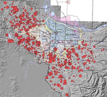
Now, Portland State University has some even better maps with much more detail on how Measure 37 is affecting farmland around metro Portland. Here’s my favorite, in miniature (the original is a big image):
Obviously, the dots aren’t to scale; they’re much larger on the map than in real life. Still, if you like farmland—and Portland’s well-deserved reputation for controlling the worst excesses of exurban sprawl—you can’t help but be a little sad about what’s happening in the Portland area right now.
I suppose that some people call this sort of thing progress. Perhaps that’s the saddest thing of all.


