
Ever wonder where your electricity comes from? Look no farther than this nifty map of Northwest electric power generation, from the website of the Northwest Power and Conservation Council, the regional coordinating body for the electricity sector.
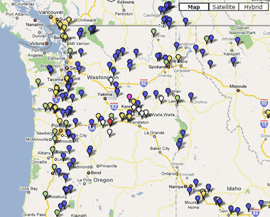

Most interesting to me, the map lets you look at generators by type—hydro, natural gas, wind, coal, biomass and nukes. And when I play around with the map, two things stand out.
First, there are an awful lot of hydropower dams around these parts! They’re all the blue dots in the map above. (For more on this point, see our maps of dam development in the 1930s, 1960s, and late 1990s in the region.)
And second—despite all that hydropower, there’s still a lot of fossil fuel energy in the system as well—particularly from the distant coal plants that supply some of our winter power. So while wind farms are certainly spreading nicely, we’ve still got quite a job to do to wean ourselves from the most polluting, climate-unfriendly power sources.


barry
Thanks for the great resource for those of us working to understand our carbon footprints and take action accordingly. I’ve found this site also helpful for understanding where the big ghg power stations are: http://carma.org/. Sightline has been doing a great job tracking fossil fuel use and emissions data and making policy and lifestyle suggestions. However there is one point that nobody seems to be covering about electricity use: “when do we need to start transitioning from personal fossil fuel use which will never be low enough ghg -> to personal electricity use which can be?” Put another way, the IPCC and many others say we have to quickly create a lifestyle that emits no more than 1 tonne of ghg per person. George Monbiot’s recent calculations based on today’s data shows that only a total de-carbonizing of the entire economy by 2050 can save us from dangerous climate change. Either scenario means that personal burning of ANY fossil fuel (natural gas, propane, gasoline, diesel, heating oil) in any quantity has to ramp down and stop. Since machines and appliances last for decades, the fuel-transitioning has to happen decades before the required ghg target for that sector. So, at some point very soon (already?) society needs to begin transitioning homes and transportation away from fossil fuels. Fossil fuel machines and appliances that last for decades are being purchased by the millions. These are inflexible responders to the need to lower ghg year by year. They have locked in ghg emissions for the usable lifetime of the machine or appliance. At some point, that part of the economy either must be used less or abandoned.Yet, everywhere I look I find the same advice: buy new cooking stoves, heaters, hot water heaters, driers and transportation that burn fossil fuels directly. Do not buy electric for any of these. Just this month I’ve heard this argument from:* Sightline reports* RealGoods Solar Living Source Book* my local “alternative energy” supplierWe have a “planetary emergency” that could slide to “irreversible” unless we quickly and radically de-carbonize our lives. We have clear info from environmental community that we soon have to dramatically reduce and then stop using fossil fuels without carbon capture. And we have strong advice from almost all environmental thinkers/groups to buy more multi-decade fossil-fuel burners. Clearly these two things are on a collision course.It seems to me that people wanting to lead the change should first do the “reduce, reuse, recycle” stuff and then consider electrical options and buying “green power” to run them. What am I missing? Timing I assume. Are there people talking about the required fuel-switching transition timing and scale? There is a very depressing set of ads in the latest National Geographic magazine. It shows people wantonly destroying perfectly good appliances just because they want the new model. At what point are we going to force the ghg-required equivalent of this? Does it matter in the big picture?In two or three decades, nobody will be burning fossil fuels directly at home. How do we get there? When do we start?I’d sure appreciate any links or discussion of this. If it hasn’t been done well, I’d love to see Sightline take up this issue. Thanks as always for all the great work,Barry
Clark Williams-Derry
Great question, Barry. I don’t have an easy answer.To me, the nut of your question: if the ultimate goal is to de-carbonize the economy—and there’s no way to do that when you burn fossil fuels directly—when should people stop buying gas-fired furnaces, and start buying, say, electric furnaces?My general response is: when we have a policy in place that gradually eliminates coal & natural gas from our electric generation portfolio, we can probably start switching from direct fossil consumption over to electricity. But as long as coal is the marginal electricity source in the regional power grid, it probably makes sense to focus on super-efficient (but still fossil-burning) cars & appliances.Note: THIS IS JUST THINKING OFF THE CUFF!! It’s not based on any deep analysis—just a general observation that coal-fired power is still the GHG boogeyman, so anything we do to boost baseline electricity demand is counterproductive. But the actual switchover date—gee, I dunno. It’d probably take a bunch of economic modeling to figure all that out. Also note that there are applications where electricity still makes loads of sense—heating homes with ground source heat pumps is already more climate-friendly than using natural gas directly. It’s just super expensive to install, so right now there are probably other things you can do with your money that have faster & higher GHG paybacks per dollar.I hope that starts to answer your question…
barry
Thanks for the reply Clark!I’ve been posing this question to lots of eco-energy folks and I’ve never got anyone to address the conflict between the need for a super-low-ghg future and the urging of people to buy long-lived fixed-ghg infrastructure.You’ve re-stated my question very well. What we really need is to figure out the timing of this transition. At the very least we need to be discussing openly that this will need to happen soon. We can’t afford to be buying ff-burners in 10 years. I think we are already behind the curve.I strongly feel that “direct” ghg emissions need to fall far faster than “non-direct” ghg emissions…so transition timing for personal fossil fuel -> electricity must happen sooner than for economy as a whole. We have many usable and affordable electric alternatives for personal needs…and much fewer for freight, farming, concrete and so on. Also, this transition timing has to happen sooner than many machines and appliances will wear out. In other words, transition needs to be happening now…the question is what it the rate.A related point is that many energy issues are looked at via “right now” conditions. But conditions are now changing very rapidly. One example is your Prius Smackdown research. The result varies dramatically with future energy scenarios. Throw in a climate change carbon-tax and reduced supply vs. demand…and you get a future likelihood of much higher gas prices and so very different weighting. Because a Prius lasts for decades the balance of the equation needs to take all those decades into account when purchasing today.Ditto for fossil fuel burners. Sure the marginal grid might be coal dominated now…but how likely is that over the lifetime of a new gas stove or gas car? Very unlikely if we are going to have a survivable society. If we aren’t, who cares what we use now.As you know, BC has already declared all future electricity gen will be zero-ghg. Washington has rejected a coal plant based on law outlawing high-ghg per kilowatt…effectively killing coal in washington. New Zealand and Australia have both announced “no new coal”. George Monboit’s recent article says “To stabilise temperatures at 1.5 ° above the pre-industrial level requires a global cut of 100%. The diplomats who started talks in Bali yesterday should be discussing the complete decarbonisation of the global economy. It is not impossible. In a previous article I showed how by switching the whole economy over to the use of electricity and by deploying the latest thinking on regional supergrids, grid balancing and energy storage, you could run almost the entire energy system on renewable power. This could account for around 90% of the necessary cut. Total decarbonisation demands that we go further. Preventing 2 ° of warming means stripping carbon dioxide from the air. ” Sounds like we need a Monbiot-future vs Lovins-thermodynamic-effeciency smackdown.Finally, as i pointed out in another recent comment, people can pay for new low-ghg power directly via green energy suppliers. This is equivalent to buying organic food. People and society have the ability, and necessity, of dramatically lowering the ghg/kWh of the grid over the lifespan of the machines and appliances being built today.At some point eco-energy thinkers have to be advocating transition to 100% electricity for everything and the buying of green energy to power it. I think we are already past that point…but i’d love to see it explored in more detail by somebody.Again thank you for your response and being open to the concept that climate change is forcing us all to re-think energy truisms as conditions so dramatically change in our understanding of present and future. Who knows what rate the transition needs to happen at…but it absolutely must. It’s heartening to have an eco-energy expert like yourself thinking about this issue.