
Oh, Google, what would we ever do without you? Check out this Google Maps-generated image of the region near Cannon Beach, Oregon:
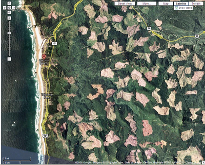
The strange patchwork of brown? Those are clearcuts in the Coast Range. And many of them appear to be recent.
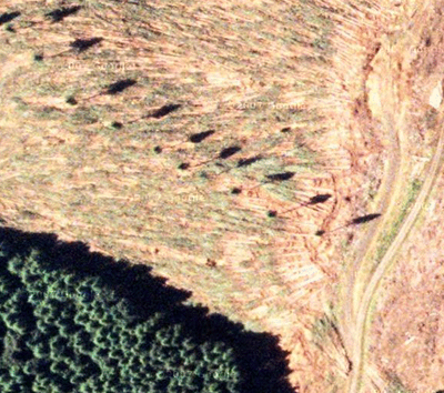
What’s really great is that you can zoom in so close that you can clearly see the bulldozed logging roads, a line of “leave trees,” and a striated green that I’m guessing is first season re-growth of vegetation. See::

I’ll bet some tech-savvy map-genius type could collate enough Googe Map images together to do a systematic analysis of clearcutting. I could imagine starting in just one region—perhaps a single Oregon county—or expanding the analysis to include a large swath of the Pacific Northwest or even North America.
Why am I so fascinated by this?
Because back in the day we used satellite images to monitor clearcutting around Cascadia. We made pretty nifty maps—some of them animated—showing 30 years of cutting. Here’s one that we made for a section of the southern Oregon coast.
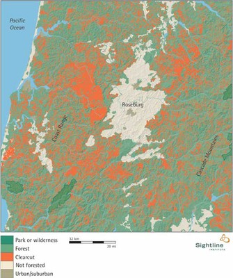

All that red shows clearcutting since the early 1970s. And, yes, it’s a lot of clearcutting.
These maps made a bit of a splash, and we were intending to update them every year or two. But then the imagery from the satellite became defective; and rather than fix the satellite, the US government opted to redeploy the money to the Mars space program (at least that was the word at the time).
We were bummed out.
But with the wealth of imagery available from Google Maps (not to mention Google Earth), it seems almost possible to use Google’s free public images to construct a new and ongoing analysis that would track clearcutting as often as the images are updated. By calculating acreages it should be possible to develop an ongoing forestry score—with supplementary pictures!—to show how logging practices are actually happening. No doubt there would be some technical issues to sort out, but I don’t think it’s anything that some tech-savvy map-genius type couldn’t handle.
Anyway, it’s intriguing stuff.
Credit for this post really belongs with Clark; he came up with the idea.


Bob Howell
Those are not leave trees. They are jack trees to be used in suspending the logs while yarding. They will be cut down when not needed. The green on the ground are tree tops as the timber to be logged is still on the ground
Eric de Place
Thanks, Bob. That’s helpful.Which reminds me: any mapping enterprise like the one I described will benefit from robust “ground-truthing”—i.e. actually checking physical locations in person to see if the maps match reality. Good ground-truthing can help cartographers make better judgments about what the images reveal. It’ll be interesting to zoom in on the same area once again, after Google next updates the sat images.
mike
Pretty good definition! Odd, that the trees are still up since I can’t see the yarder. Maybe they’re counting as seed trees.
Dave
Eric, GoogleMapsEarthEverything is way cool, but what you are suggesting has already been done by remote sensing researchers. Warren Cohen of the US Forest Service PNW Research Station in Corvallis, Ore. (and his band of intrepid remote sensers) pulled together Landsat images from 1972 to 1995 to identify areas of stand replacement disturbance (clearcutting and fire). For those with GIS savvy, the data layers are available. They have since been updated through 2002 or later.Cohen, W.; Spies, T.; Alig, R., et al. 2002. Characterizing 23 years (1972-95) of stand replacement disturbance in western Oregon forests with Landsat imagery. Ecosystems. 5: 122-137.It might be possible to do what you’re proposing via Google, but I don’t think it’s particularly easy to get Google to give you different imagery dates. And things may have changed, but it hasn’t always been easy or possible to figure out what year or type of imagery Google was using.
David E. Ortman
The Native Forest Council out of Eugene, ORhttp://www.forestcouncil.orghas long documented the impacts of clearcuts using photographs. Check out their website.