
 What if cities had no sidewalks and everyone walked on the road? Or, for urban recreation, they walked on a few scenic trails? What if the occasional street had a three-foot-wide “walking lane” painted on the asphalt, between the moving cars and the parked ones?

Well, for starters, no one would walk much. A hardy few might brave the streets, but most would stop at “walk?! in traffic?!”
Fortunately, this car-head vision is fiction for pedestrians in most of Cascadia, but it’s not far from nonfiction for bicyclists. Regular bikers are those too brave or foolish to be dissuaded by the prospect of playing chicken with two-ton behemoths. Other, less-ardent cyclists stick to bike paths; they ride for exercise, not transportation. Bike lanes, in communities where they exist, are simply painted beside the horsepower lanes.
Cascadians react reasonably: “bike?! in traffic?!” And they don’t. “It’s not safe” is what the overwhelming majority of northwesterners say when asked why they bike so little. (As it turns out, it’s safer than most assume—on which, more another day.)
So what would Cascadia’s cities look like if we provided the infrastructure for safe cycling? What does “bike friendly” actually look like?
 Good bicycling infrastructure is something few on this continent have seen. It doesn’t mean a “bike route” sign and a white stripe along the arterial. It doesn’t mean a meandering trail shared with joggers, strollers, and skaters.

Bike friendly means a complete, continuous, interconnected network of named bicycle roads or “tracks,” each marked and lit, each governed by traffic signs and signals of its own. It means a parallel network interlaced with the other urban grids: the transit grid on road or rail; the street grid for cars, trucks, and taxis; and the sidewalk grid for pedestrians. It means separation from those grids: to be useful for everyone from eight year olds to eighty year olds, bikeways on large roads must be physically curbed, fenced, or graded away from both traffic and walkers. (On smaller, neighborhood streets, where bikes and cars do mingle, bike friendly means calming traffic with speed humps, circles, and curb bubbles.)
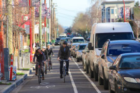
Picture a street more than half of which is reserved for people on foot, bikes, buses, or rail; on which traffic signals and signs, street design, and landscaping all conspire to treat bicycles as the equals of automobiles. This is what bike friendly—what Bicycle Respect—looks like.
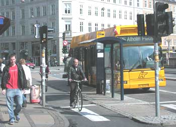 |
Such “complete streets” are common in Denmark, the Netherlands, and other northern European countries. This photo is from Copenhagen, which has more than 200 miles of “bicycle tracks” and another 40 miles planned or under construction. (Photo courtesy of Jayson Antonoff, International Sustainable Solutions. See more photos here.) These tracks, which are typically above street grade and below sidewalk grade, can move six times more people per meter of lane width than motorized lanes of Copenhagen traffic. That’s right: because cyclists can travel close together, bike tracks have higher traffic “throughput” than do car lanes. Copenhagen has even synchronized its traffic signals—for bikers. An average-speed bike commuter going downtown will rarely see a red light.
What does bike friendly look like? It looks like a 60-year old and her granddaughter on two wheelers, getting the green light at each intersection they approach, while drivers brake to stay out of their way.
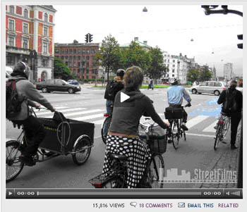
What does bike friendly look like? Watch this video to see. Though it’s Big Apple-centric, it includes footage of physically separated bike lanes from around the world. (Note: The eight-minute video buffers slowly; you may want to start it loading in another browser window and return to it after you finish reading. The image below is not a live link.)
  |
(Aside: If you’re part of the YouTube generation and want to see more video of bike-friendly cities, there is plenty to choose from. The best I’ve found online are Copenhagen—City of Cyclists made by the city government and Amsterdam: The Bicycling Capital of Europe.)
Compared to these two-wheeled meccas, how bike friendly are Cascadia’s cities?
They’re not. Even leading cycling cities such as Corvallis and Eugene lack continuous, interconnected grids of physically separated bikeways. It’s true, Corvallis has painted bike lanes on almost all its arterials. Eugene has 33 miles of separate bike paths, and it lights many of them at night. But they’re more of a recreational resource than a transportation network, because they don’t form a grid. These towns are North American models, but they’re still a long way from bike friendly. You wouldn’t send your eight year old to school or soccer practice on these bike lanes.
 The big Cascadian metro areas all lag these smaller cities, though they’re above average, by North American standards. Among them, Portland and Vancouver have invested more aggressively in bicycle infrastructure than has greater Seattle. And both are exploring new forms of bikeways to attract new riders, such as converting neighborhood streets into calmed, “bicycle boulevards” or greenways.
Vancouver, BC, is the cycling-est big city in the Northwest, and the City of Vancouver has been inserting bike routes into its urban grid at a pace of one mile every two months for almost two decades. It has emphasized waterfront bike paths and calmed, side-street bike lanes. (See, for example, this report [large pdf], especially pages 37-44.) The greater Vancouver area boasts an impressive 1,500 miles of designated bike routes, but most of them are just white lines in traffic.

  |
The City of Portland has expanded its bikeways fast in recent decades, as shown in this animated map of bike routes over time. (Static maps [large pdf] courtesy of City of Portland, Office of Transportation. Thanks to Clark for animating.) It’s also shown in the chart below. The city has added them at a pace approaching one mile a month since 1980, outstripping even Vancouver. In fact, with 277 miles installed in Portland, the Rose City now claims more bikeway miles than Copenhagen.
  |
The City of Seattle reports 67 miles of bike paths and lanes, plus another 90 miles of signed bike routes—a fraction of Portland’s network. The greater Seattle area has about 470 miles of paths and bike lanes, which is one third the total in greater Vancouver, a smaller, more-densely settled metropolis. The emphasis in the Puget Sound region, according to the Cascade Bicycle Club (large pdf), has been on building recreational paths shared by bikers and pedestrians, not building transportation infrastructure for human-powered travel. Tacoma is especially ill-fitted for bicycling at present, as the News Tribune recently reported.
Of course, raw numbers of bikeway miles are difficult to interpret. Researchers John Pucher and Ralph Buehler (pdf) adjusted reported bikeway length for population size in various North American cities, determining that Portland has 38 bikeway miles for every 100,000 residents, while Vancouver, BC, has 18 miles and Seattle has 9 miles. But these figures conceal as much as they reveal: a low value may reflect either fewer bikeways (for example, in Seattle) or higher population density (for example, in Vancouver).
Moreover, the quality of biking infrastructure matters as much as the quantity. Slapping a “bike route” sign on a road may qualify it for a city’s registry but doesn’t help cyclists much. Conversely, traffic calming on residential streets may make entire neighborhoods bike friendly without adding a mile to the bikeway count. Portland claims to have more miles of bikeways (277) than Copenhagen (204). But two-thirds of Portland’s are white lines on the pavement, while Copenhagen has an integrated, continuous network of physically separated bike tracks. Consequently, Copenhagen’s bike “mode split”—the share of all trips taken by bike—is ten times higher than Portland’s.
Cascadia is no novice at building bike-friendly cities, but we may be no more advanced at the art than apprentices. Still, our intentions are good. Take, for example, the City of Seattle’s Bicycle Master Plan—an official policy document that’s in the final stages of public comment and review. The plan will guide the cyclo-fication of the city over the next decade. If fully implemented, the plan will bump the bikeway count up to 452 miles and put bike lanes on 62 percent of arterial streets—reaching within a quarter mile of 95 percent of city residents. The plan doesn’t envision groundbreaking on northern European-style bike tracks, but it does raise the bar in Cascadia’s largest city, setting it on a trajectory to catch up with its neighbors.
The question is, which Cascadian city will push on into the realm of true bike friendliness—of true Bicycle Respect? Doing so may not be politically easy, because in most cities, it will require taking street space away from cars and trucks and converting it to separated bikeways. The benefits will be immense and immediate, because bicycles are clean, healthful, democratic, fun, and affordable for all classes.
But who will lead the way?
Until some city does, until we can see “bike-friendly” right here in Cascadia, most northwesterners will continue to say, “bike?! in traffic?!”
(Thanks to Deric Gruen, who did research for this series.)


Rich
bike?!in traffic? The perception is that it is unsafe but there is more. The perception of your average person(the type of person you would want to see replace a few car trips with bike trips) is that bike commuters are “them” in an us vs. them scenario. They are part of a little tribe with all the little markers and secret handshakes etc. People on bikes need to be seen as just people not bike people. What divides a “regular” person on a bike from a “bike person” on a bike. I asked around and the number one indicator was whether or not they have a helmet on. Then I look at the photos in Amsterdam or the youtube clip in NY above and realize the helmets aren’t being worn all the time by everyone. This seems silly and I don’t see any bike advocacy groups downplaying the importance of the helmet but I think this is a real problem for bike respect.
Alan Durning
Rich,Interesting perspective, Rich. Each of us is a car-head. Each of us is a potential biker.But you’re right that, in the absence of safe bikeways for all, the profile of current bikers is certainly tilted toward people with higher risk tolerance.Our vehicles—like our clothes—are cultural markers. They say which group we belong to, in an anthropological sense. And current bikers may be somewhat identifiable by the cultural marker of their bikes (and associated accessories). But first, bikers are, in fact, several different groups. For example, I’m a bike commuter and even own some biking clothes (all of it ratty and bought used) but I definitely do not belong to the group of unhelmeted messengers on fixed-gear bikes (“fixies”).And second, I have a hard time believing that us-them psychology is a terribly important influence on how much biking anyone does.And I disagree with you that bikers’ use of helmets somehow dissuade nonriders from biking. Maybe the spread of fancy, high-end bikes and specialized biking clothes is off-putting to a few. Maybe the reckless attitude of a small minority of cyclists, who flout traffic laws, is off-putting. But helmets? I don’t think so. Besides, the huge elephant in the cityscape is not the cultural dimension (in-group bikers v. out-group nonbikers). It’s traffic. It’s the legitimate fear of injury or death. It’s the absence of safe bikeways.
scotth
I agree that by far the biggest factor for why more people don’t bike is that many people do not feel safe or comfortable biking in traffic. But I do think helmets, clothes, etc. are a factor too. My sister has lived in Holland for almost 4 years now, and when I visited her a couple of years ago, I was struck not only by the amount of biking, but also that VIRTUALLY NO ONE wore helmets. When people want to go to the grocery store or go to a cafe or something, they just hop on their bikes and go. They don’t have to mess with putting on spandex or helmets and they know there will be a bike rack wherever they go. Everything that makes biking even a little more convenient increases ridership.
Alan Durning
The North American response to bicycle safety challenges has been, largely, to encourage helmets. Call this the personal responsibility approach.The European response to bicycle safety challenges has been, largely, to separate bikes from cars and trucks. Call this the common good approach.The record shows, clearly, that the common-good approach works better for biker safety (I’ll blog about the statistics in a few weeks). It also shows, clearly, that the common-good approach works better for safety more broadly: for pedestrians, cars, human waistlines and lungs, local economies, national energy systems, global climate . . .
dhwert
I don’t think the psychological factor should be discounted too quickly. Is someone likely to start biking if no one in their peer group bikes?This may be especially noticeable in youth. A friend of mine asked the youth at our church why they don’t bike to school. Although they know all the reasons why they should bike rather than drive, apparently the “cool factor” wins the day. If they’re saying this in a bike-friendly city like Corvallis, how much more challenging must it be in other places.Also, if helmets aren’t off-putting, then why do none of the Copenhagen bikers in those photos have a helmet on? Not a one!I guess this means we need to design bike friendly cities to the point where people feel safe enough not just to bike, but to bike without helmets.
Matt the Engineer
“it will require taking street space away from cars and trucks” I thing the word require is too strong. I think raised bicycle freeways could be made in an affordable and very useful manner. These would remove traffic lights, traffic, and interaction between traffic streams from the equation, level out hills, and could really be a quick way into and out of any downtown area.My concept of a raised bicycle freeway was inspired while walking in downtown Seattle a few months ago and looking up at the eves over every storefront. “Wouldn’t it be nice if we could ride on those” I thought to myself. Well, why not? We’re not talking about the amount of structure needed for something like a freeway overpass or the Monorail. I’m thinking of a structure similar to pedestrian overpasses that are 2 bikes wide (~8′?), are one-way, and run over sidewalks in a few locations downtown. Every few blocks is an on- or off-ramp that goes down to street level. For Seattle, let’s say one travels all the way through town on 6th, one on each side. Maybe another one down on 2nd. Maybe even connect the two south of the city, to make the climb uphill much more gradual. You could then either stay elevated while going out to the neighborhoods, or bring it down to street level.It’s hard to imagine this without a sketch… here, try this (not to scale, just a quick sketch).
Freya
I am a bike commuter in Vancouver and have cycled in both Denmark and the Netherlands. I have also noted that very few people (aside from young children) wear helmets in these “bicycling meccas”, however I believe there are four good reasons for this. #1 Cycling is much much safer in these countries because of the bike infrastructure; #2 Drivers are well trained to share the road with cyclists; #3 These are relatively flat countries – you don’t go very fast!; #4 Most people ride heavy, unwieldy, steel-framed Dutch bikes with often no gears and no hand brakes. On the other hand, in large cities like Vancouver or Seattle, it is only the very ambitious who are able to ride up the large hills on bikes like this. When you are going slowly on a heavy, sturdy bike you are much less likely to fall off and bump your head! In short, I doubt hilly cities will ever be safe enough for cyclists to go helmet-free. Especially if we continue riding our Norcos!
David Hiller
Alan:First, thanks for speaking at the Bike to Work Day Rally this morning and for continuing to work on this series.Before getting into the issue of “bike tracks,” I want to confirm for your readers that percieved safety has been repeatedly found to be the number-one determinant for those who choose not to ride. Ironically, the study “Safety in Numbers” (Jacobsen, 2003) showed that the more bicyclists and pedestrians there were on the roads – the lower the accident rate (fewer accidents per user). Portland’s numbers bear this out. They’ve had a 600% increase in bicycling in 20 years and NO increase in accidents (so 1/6th as many accidents per cyclist).On the issue of Copenhagen style “bike tracks,” though I appreciate your intent, I feel you should know a few things about why planners and engineers oppose this type of configuration. Locating bicycle facilities between parked cars and the street edge has far more disadvantages than advantages in our CURRENT cities in the region. For example, vehicles exiting driveways or intersecting streets would need to completely obstruct the bicycle facility to be able to see around parked vehicles. Further, vehicles turning off such a road would be unable to see bicyclists travelling behind parked cars and trucks. For these and many more reasons, this type of treatment is specifically rejected in all of the engineering manuals on the subject. Their success in Europe is largely due to huge numbers of cyclists, which makes it impossible to forget they’re there. Volumes ten-times greater than our busiest trails – where right of way problems exist despite the constant presence of users.(Its also helpful that they have supportive land-use, 100% tarriffs on autos, flat terrain, etc.)Like you, I hope we get to the place where those facilities work for our communities. The Seattle Bicycle Master Plan is a great step in that direction, by building the kinds of infrastructure that we KNOW attracts new riders.Take care and thanks for riding,David HillerAdvocacy DirectorCascade Bicycle Club
Frank
Freya has a point: in a flat city like Amsterdam, even a little old lady can bike around all day and barely break a sweat. Bicycling Seattle’s hills requires much more physical strength and stamina. It’s never going to be as widely adopted as it is over there, for the simple reason that not as many people are in such good shape.(Sure, we can take pot-shots at the “fat Americans,” but many of Amsterdam’s less-physically fit residents would have to give up their bikes if they moved to Seattle.)Who knows, maybe I’m biased, as a guy who biked to work every day until I moved to the top of Queen Anne Hill. 🙂
Alan Durning
dhwert,Put a nonbiker in a bike-friendly city and I bet s/he’ll start biking—with or without peer influence.But temper that comment by an acknowledgment that behavior diffuses through the normal stages: pioneers, early adopters, the big middle, and the laggards. Social connections are important in this process.As for youths, I hear countless anecdotes about bike-riding kids who grow into bike-shunning teens. Theories abound: Biking is seen as childish in our culture (dependent, weak) while car-driving is seen as adultlike (independent, powerful). Teens become appearance conscious, so don’t want helmet-head. Etc.To me, the big point is that the “teach the children” strategy is dubious. Children, and teens, learn mostly from the behavior modeled by their parents and other key mentors. They absorb it. They differentiate themselves from it—often by partially rejecting it. Then they achieve adulthood and independence: and they return to many of the behaviors they learned earlier. So bike-shunning Corvallis youth will mostly, I suspect, turn into bike-riding adults (again, if they land in bike-respecting communities).In general, I think we worry to much about what teenagers do, and not enough about what adults do.Matt,I like your sketch. I’m guessing elevated bikeways would be even less popular than taking away street space, because building owners won’t want a bikeway in front of their second-floor windows. But I think it’s a cool idea, worth trying out.Freya,I think you’re right on all counts. One other factor that’s important in explaining the helmet difference between Europe and North America is simple social diffusion theory. Helmets reached a tipping point here, they never did in Europe. The explanation of the difference is, likely, a few things—some that you mentioned and the one I mentioned. North America is culturally more oriented around the individual and so we see social problems as matters of personal responsibility. Hence, bike helmets. Europe is a little less individualistic. So collective responses for the common good hold greater appeal.David,Thanks for your informed comments, and for your leadership for the Bicycle Master Plan. It’s a huge step and deserves great praise.You’ve got more expertise than I in this area, so I should probably stop now. But I won’t.You raise some good points about the challenges of building physically separated bikeways in the context of ubiquitous curbside parking.A couple of rejoinders:1. I think you’ll note in my blog post (as opposed to the Street Films video I linked to) that I didn’t specifically say to put the bikeway behind the parked cars. I’m agnostic on that specific issue. The parking could be in front of the parked cars, as long as it’s elevated enough to slow cars way down before carefully crossing it to park. What I said was that there needs to be enough physical separation to keep bikers away from moving cars. A variety of designs come to mind, and some are referred to in the video. One of the simplest, though challenging politically, is to eliminate curbside parking in places where no other design solution is available. 2. I find the specific examples you site somewhat persuasive. I find this statement, though, singularly unpersuasive: “this type of treatment is specifically rejected in all of the engineering manuals on the subject.” Traffic engineering manuals are, to me, a highly suspect source of guidance: they’ve got about 50 years of city-destroying bad karma to work off before I’ll take them as a reliable and enlightened guide. Yes, I know, they’ve changed. But still, I’m much more persuaded by what works in practice in real bike-respecting cities than I am by the reductionist engineering approach. In theory, woonerfs shouldn’t work, but they do. In theory, bike tracks behind the parking lane shouldn’t work, but . . .3. I’d much rather discuss the details of bike track design with you than continue debating the whys and whats of helmets in Cascadia v no helmets in Europe. To me, that seems like a distraction.Frank,I lived on top of Queen Anne for a while. QA would be at the top of my list for a Cascadian test of the trombe—bike lift.http://www.sightline.org/daily_score/archive/2007/04/26/the-weakest-link-bicycle-neglect-2
ethan
I am a little surprised by some of the responses to Alan’s post. I respect perceptions but the argument aobut “bike people” is simply a biased opinion. In fact, the so called “bike people” I know in town all wear helmets without a single exception. Even if “bike people” were not wearing helmets and alienating people with “secret handshakes” is that a reasonable argument for others not to take a more sustainable option than the automobile. Several of the replies also commented on special clothes and similar reasons that stop people from biking. However, if you travel to other areas in the world there are many people riding in very normal clothes on very basic bicycles and doing just fine.Some say that indeed this is true but these areas are flat. I would strongly disagree on this. I believe there have been so many examples of good trasportation by cycling that use Denmark as an example. Life is great there with a bike and, yes, it is pretty flat in the cities. However, not all of Denmark is flat though and in the rolling country people are commuting by bike as well. We should also look beyond. In extremely hilly and even mountainous areas of France and Italy people are activly riding their bicycles way more than Seattlites. Heck, even in Vancouver and many smaller towns in BC there is actually quite an amazing amount of bicycle commuting. There is a better supply of inexpensive bikes with many gears for all conditions than ever at this very moment in time.I personally have my biases and they are not very pretty. However, we have a problem to tackle with how we have been using energy. Getting more people on bikes will make a significant dent in this problem. I remember hearing 10 years ago the many reasons scooters could not be written in Seattle. However, now scooters have a much larger presence in town, much as they do in many places in other countries. Certainly people on bicycles can accomplish the same.
Prof. Bijon B. Sarma
The city of parts of city designed in the above mentioned ways can easily accomodate saferiding of bikes. In fact that was my intention also, even though I symbolically transformed it into walking limit. Regards, Prof. Bijon B. Sarma, Bangladesh.
m. leber
I have commuted by bike, off and on, since grade school and want to use my bike more. In the absence of a comprehensive bicycle infrastructure in Bellevue, I use sidewalks, the odd bicycle lane, and a few low-traffic streets. While I generally “feel” safe, I do realize the dangers of my commute. Narrow sidewalks, bike lanes that simply end—merging into the street, busy intersections, and cell-phone wielding drivers are frequent danger points over here. Many days anxiety, coupled with laziness, weather, or a worried wife push me into my car. (I’m bald so “helmet head” is never a concern.)Anything the city of Bellevue does to improve bicycle access between South Bellevue and downtown as well as downtown to East Bellevue will tip the balance more towards bicycling. Improve infrastructure enough and I’ll gladly get rid of my 2nd car. It’s kept around mostly as a contingency plan anyway. (An expensive one at that)Bravo Alan, another excellent post in a vital series. As a semi-fearless cyclist that craves REAL bicycle infrastructure I look forward to more.
sf
Part of the problem is that the last generation has been protected too much. They can’t ride bikes to school or to their friends more than a mile away because there is too much perceived danger of sexual predators and traffic accidents. By the time we start to encourage our children to bike around town, it is no longer cool. I bike. Yes it is more dangerous, but I have survived to age 63. My two worst accidents were caused by a dog and a stick on a dirt road. The town where I live needs to come up with $6-8 million to fix the sewer system. This for an area served with about 4,500 people. How are we going to pay for a separate bicycle lane system. I doubt it will ever happen.
Levin
A network of greenway paths transforms local errands into safe, healthy, delightful recreation—without car exhaust or noise, and without a ton or 2 of armor strapped on, just to safely rent a video at the corner store. The most bike-friendly place that I’ve seen in North America is Davis, CA. The Davis Bike Map shows the comprehensive system of paths (shown in brown) that are physically separated from motorized traffic. Many of the paths go through greenways and parks. For instance, if you look just below the “Davis Bike Map” logo, just north of Arroyo Park, there are 2 north-south greenways with paths for bikes and pedestrians. Kids can safely ride their bikes through the neighborhood to school (there are underpasses at Shasta Drive) and to the park. Southwest of here, between Patwin School and Davis Montessori School, the Village Homes subdivision has a complete network of bike/pedestrian paths through narrow greenways. (The greenways are not shown on the bike map.) In Davis, all new developments must connect to this network of paths. The network of paths provides connectivity at a scale appropriate for walking and biking, while the street grid connects traffic at a larger scale, appropriate for driving. Some things to consider about the perceived “cost” of separate paths for biking and walking, versus driving:+ Health costs are very high (in dollars and in unhappiness) for diabetes, obesity, heart disease, depression and car accidents. All of these concerns are mitigated when people walk or bike for errands, instead of driving. + When stormwater follows a stream bed or bioswale beside a bike path, and the bike paths form a well-connected network, then underground stormsewer pipes are unnecessary. This saves money, benefits the natural environment, and enables kids and adults to enjoy the water.+ Many streets are wider than they need to be. Narrow streets save money, and leave more land available for greenways with paths. The document “NEIGHBORHOOD STREET DESIGN GUIDELINES, An Oregon Guide for Reducing Street Widths”, has buy-in from many Oregon stakeholders, including firefighters. http://www.oregon.gov/LCD/docs/publications/neighstreet.pdf + The costs of greenhouse gas emissions, today and for our children, are incredible. Every pleasant, safe, relaxing path that entices anyone to bike or walk for an errand, instead of driving, contributes to a safer, healthier future for everyone.
dsamson79
Although I believe that stumping for the collective consciousness is good and very prudent for everyone, I also believe that we would all do well to be more community minded ourselves and band together to educate each other on bike riding skills, ride route planning and traffic riding skills/coping mechanisms. I started out riding Seattle as a renewed rider in 2004 after abandoning my bike for the most part after middle school. Now I have no idea how I lived without it. A lot of what drives me to ride is the challenge in riding through traffic. Gentrification and separation of transportation modes are nice for attracting new converts, but learning to adapt and conquer the challenges that face cyclists in a car-centric world is in my opinion more important in the short-term. I can’t rightly say that I would ride any separated bikeway unless a) it was over a bridge or other obstruction or b) the general cycling public was well educated on how to share the road with others. For the latter reason, I often find myself shunning the Burke when in Seattle because many people who use the trail have no sense of courtesy towards others with respect to right of way. I cannot emphasize how aggravating it is to try to share the trail with groups of mothers 3 abreast with baby carriages who give you stink-eye when you try to pass or other walkers who are so oblivious to the possibility that someone might pass them that they spook at the sound of your voice/bell. For those reasons, I almost invariably ride the runner’s (dirt) path on the side of the burke instead to avoid those very trail users.
Erik Sandblom
I don’t think the importance of flatness should be overstated. With a suitably geared bike it’s no more difficult to bike up a hill than to walk up the same hill. And you can’t coast down the hill the other way unless you’ve got wheels.I suspect many people have their bikes geared too high because they want to go fast. But in a city, average speed is more important than top speed. I think a good rule of thumb is that your top gear should have you riding at 30 km/h. That way you get more gears for uphills and headwinds.
Alan Durning
Columnist Neil Pierce has an update on bikeways in London. “London sprang to world leadership with Mayor Ken Livingstone’s February announcement of a $787 million system of 12 two-wheeler superhighways connecting popular residential areas to the city center. The roadways will have continuous, wide cycle lanes, dedicated junctions and clear signs, cutting a swath through traffic.””Planners hope the London system will attract a “critical mass” of cyclists; even diverting 5 percent of people from their cars and the tubes and buses, it’s estimated, would result in 1.7 million cycle trips each day.””Londoners also hope to set up special cycle networks around 15 suburban towns, connecting residences with schools, train and bus stations, parks and shops.”
Pete the Engineer
I came to a similar idea independently of Matt, every day on the freeway of my long commute.I’ve been obsessed by the possibility of velomobiles for a long while too. Basically, they allow you to go nearly twice as fast as a regular bike for the same amount of effort, because the air resistance is vastly reduced. The problem is however, that in a city you are slowed down all the time, and you lose all that kinetic energy that takes so much effort to build.If you can eliminate the stopping with a system of elevated “HPV freeways”, you could get to most places at an average speed of around 30km/h, as opposed to about 6km/h or so.Couple a pervasive, multi-lane elevated HPV freeway with at the least, a slow lane and a fast lane, limited to cyclists and velomobiles, and you could make your own power as practical as fossil fuel.Of course, the destination and arrival areas have to be bicycle friendly too. The way you do this is to use traffic calming and speed limits of 30-40km/h in all other road areas but thoroughfares, and provide bridges across any thoroughfares. So basically this means you can get from point A to point B most of the way, any particular direction, without stopping (via the HPV freeway grid). It also means that outside the HPV freeway you are very unlikely to be run over by a car.
ffelix
You know, everyone constantly harps on the safety issues surrounding bicycling in traffic, or in “bike lanes” that are really just overflow parking. And, yes, I’d agree that Americans are more risk-averse than ever, if not downright frightened of our own shadows.But I’m surprised how seldom anyone even mentions as a deterring factor just now unpleasant & obnoxious riding a bike in traffic frequently is: exhaust fumes, stench of road kill, ear-splitting noise, absent shoulders, idiots intentionally forcing you off the road, constant stop & go, moron drivers trying to shout you off “their” road, or highway traffic flinging gravel or blowing you over. It gets me in a car on a regular basis, even though I much prefer to ride. It’s no surprise to me that riders you see on the road are disproportionately young men who often, like a previous poster, seem to revel in the sheer challenge of it.
Alan Durning
July 18, 2008: Jeff Mapes of the Oregonian has a good summary of exciting recent developments in and around Portland. Find it here.