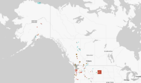
You are here: Sightline Home » Maps & Graphics » Maps

Canadian Emissions and US Equivalents

Canadian provinces and their greenhouse gas emissions from energy, with the US state equivalents.


Date range: 2002-2004

Caption: Map is based on data calculated from Environment Canada and the US Department of Energy. Emissions are an average of the period from 2002 to 2004 and include energy use only and exclude carbon sinks. Emissions are considered "equivalent" if they are within 10 percent. In 2004, more than 39 million people lived in the US states and territory named on this map; the population of Canada was 32 million.

Publication date: 2007 | Originally published in: The Daily Score | Topic(s): Energy & Climate | Graphic type: Map
Download this graphic
Log in or register for free access to premium content.
Small 350x372 px, 72dpi, 25K
Medium 565x600 px, 72dpi, 55K
Large (hi-res) 847x900 px, 72dpi, 110K
Choosing the right version
Please read our Free Use Policy
Now On the Blog
Boardman Roundup
Oregon's coal plant hangs in the balance.
Jennifer Langston 08/31/2010
R52: The Olympian Makes Sausage
Referendum 52 isn't confusing at all.
Roger Valdez 09/01/2010
Broken Home
Can declines in home sales mean a different kind of American Dream?
Roger Valdez 08/25/2010
Social Bookmarks
FlickrFacebookTwitter
 
send feedback or bugs about sightline.org to ask_us@sightline.org
site credits | premium content icon = premium content; free registration required