Location: Seattle, WA
 A new mapping analysis by Sightline Institute offers stark testimony to the potential damage of Measure 37 claims on Oregon’s leadership in protecting farmland and open space. The state’s landowners have filed more than 7,000 claims between 2004 and 2006. In the Portland metro region alone, approved residential applications for Measure 37 waivers could add nearly 14,000 housing units to the area—a startling number.
The Portland-area claims could add as many as 34,000 new residents—the equivalent of scattering the entire population of Lake Oswego into the rural areas surrounding Portland—according to the analysis by Sightline Institute. See the maps at: http://www.sightline.org/research/m37maps.
Sightline’s unique analysis estimates the number of new people and dwellings that could appear in areas that are currently protected as open space across Oregon. The four maps cover greater Portland, the Hood River Valley, and the Willamette Valley and they illustrate potential Measure 37 development in relation to current growth boundaries. The analysis shows that:
- Portland metro region: Claimants have filed more than 2,000 residential applications for Measure 37 waivers. Together, these claims could add nearly 14,000 housing units and 34,000 new residents, mostly on the urban fringe outside of agreed-upon growth boundaries.These greater-Portland-area Measure 37 claims could result in nearly as much sprawl in rural areas as Clark County, Washington, home to Vancouver, endured during the entire decade of the 1990s.
- Willamette Valley region: From Salem to Eugene, property owners have filed more than 1,000 claims for new residences. These filings could add almost 18,000 new housing units and 33,000 new residents, also mostly outside of current towns and cities.
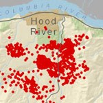
- Greater Hood River region: In both Hood River and Wasco Counties, more than 250 residential Measure 37 claims have been filed. The two Sightline maps of this region show the claims in relation to current agricultural lands and the distribution of the nearly 6,000 housing units and 14,000 people the claims could add, particularly in the Hood River Valley.
- In the Hood River Valley alone, 22 percent of protected farmland is threatened by Measure 37. Claims for new residences have been filed on properties that total 5,447 acres of agriculture. Outside of agricultural areas, more than 5,000 additional acres of the Hood River Valley could be affected by new housing claims.
“If left unchecked, Measure 37 will accelerate sprawl and endanger many of Oregon’s prized areas such as the Willamette and Hood River Valleys,” said Sightline’s senior researcher, Eric de Place. “Sightline’s maps show how Measure 37’s anything-goes approach to development threatens farms and open space.”
Sightline’s original analysis converts residential claims into estimated new housing units and residents using county-specific occupancy rates and household sizes. This November, Oregon voters will vote on Measure 49, which will reduce the impact of Measure 37 by limiting large-scale developments on protected land.
You can view the full maps at http://www.sightline.org/research/m37maps
Sightline Institute is an independent, nonprofit research and communication center that tracks trends critical to the Pacific Northwest’s future, including Oregon.