
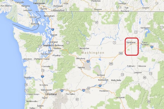
As debate heats up over coal exports and oil shipments, Sightline is analyzing public at-grade rail crossings from Sandpoint, Idaho to Cherry Point, Washington.
If fossil fuel companies succeed in shipping the volumes of fuel they have planned, they will—by sheer physical necessity—disrupt vehicle and rail traffic all along the rail route. In the first installment in this series we examined street closures in northern Idaho. In this chapter, we visit Spokane County, Washington.
Coal and oil trains—loaded in the interior of North American and bound for the coast—will close off rural roads and city streets alike for hours each day.
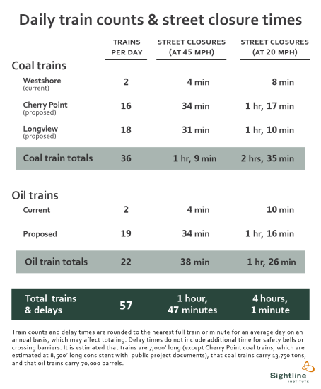

Importantly, the list of cities and crossings we analyze here is not comprehensive. Rather, we depict several representative locations in Spokane County. In each of these places, we estimate that new coal and oil trains would close streets by an average of between 1 hour and 47 minutes and 4 hours, each day, depending on train speeds.
Note that all images throughout this series can be clicked for enlargement.
As trains cross the Idaho border into Washington’s Spokane County, they pass through the small town of Otis Orchards. Rail lines and roads intersect at four public grade crossings:


Otis Orchards, WA: McKenzie Road, Harvard Road, Barker Road, and Flora Road
About 50 trains pass through these crossings daily, meaning that coal and oil trains would roughly double existing freight rail volumes at the intersections. Each of these four crossings is protected by gates that are designed to lower when trains are approaching. The Barker Road crossing sees the most automobile traffic, with 1,250 vehicles on an average day. The Flora Road crossing is the nearest to a public school, Skyview Elementary, designated with a “children crossing” icon above the leftmost red rectangle above.
Proceeding west into the city of Spokane Valley, five more BNSF public grade crossings straddle the Spokane River:
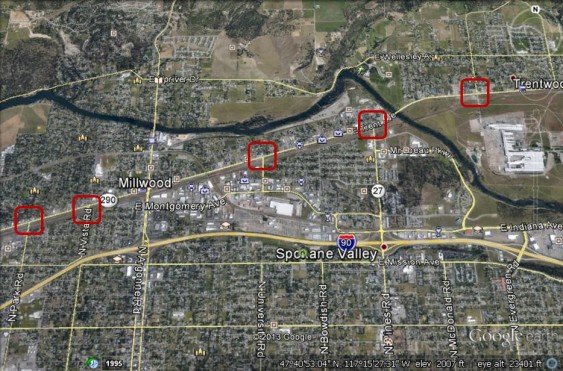

Spokane Valley, WA: Evergreen Road, Pines Road, University Road, Vista Road, and Park Road
As in Otis Orchards, each crossing is protected by gates and each crossing sees 50 trains pass by daily. The busiest street is Pines Road (also called Route 27), where the crossing sees about 11,000 average daily vehicles. North of the Pines Road crossing, at a bend in the Spokane River, the green soccer player marks the Plantes Ferry Athletic Complex, which includes fields for softball and youth soccer teams. Church icons also depict multiple houses of worship in the immediate vicinity.
As coal and oil trains continue west, they next encounter street crossings in Washington’s second most populous city, Spokane:
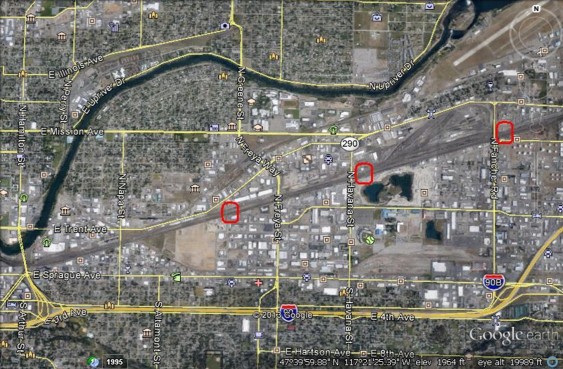

Spokane, WA: Airport Street, Alki Avenue, Fiske Street
There are multiple grade crossings within the city of Spokane, but because there are several arterial overpasses or underpasses that enable vehicles to avoid trains, street traffic at these crossings is very minimal. The image above shows three at-grade crossings: Airport Street, just to the east of a BNSF railyard, a crossing designated as “Alki Avenue” in official records, and Fiske Street. (Technical note: we identified anomalies related to many of the numerous at-grade rail crossings in Spokane, perhaps owing to data or reporting discrepancies between the Federal Railway Administration and the railroads.)
To the north of Fiske Street, just south of the Spokane River, the buildings and athletic fields of Spokane Community College are visible. To the west, on the north side of a bend in the River, are the buildings and athletic fields of Gonzaga University. To the east of Havana Street, a baseball icon represents the stadium of the Spokane Indians, a minor league team.
From Spokane, trains continue southwest on the BNSF mainline to encounter three at-grade crossings in the college town of Cheney:
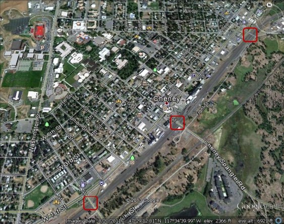

Cheney, WA: Pine Street, ‘H’ Street, and Cheney-Plaza Road
Cheney is home to Eastern Washington University. Its iconic football stadium, with a red field is visible in the northwest corner of the photo above; nearby are University buildings and other playing fields. BNSF public grade crossings include Pine Street, to the north; ‘H’ Street (actually located at F Street, downtown); and Cheney-Plaza Road (which turns into K Street at the south end of the City). Each crossing is protected by gates, and BNSF reports that 37 trains pass daily through each of these crossings.The busiest is F Street, which sees roughly 2,300 vehicles on a typical day.
From Cheney, coast-bound fossil fuel trains continue on into rural eastern Washington, soon encountering the little community of Tyler:
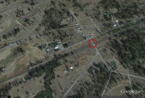

Tyler, WA: Pine Springs Road
There are four BNSF grade crossings in or near Tyler, including this one at Pine Springs Road (B Street). It is protected by gates, and currently sees 37 trains on an average day—a figure that would be dwarfed by the coal and oil trains planned for by projects in western Oregon and Washington.
Trains then continue southwest, crossing into Lincoln County, which we will analyze in the third installment in this series.
John Abbotts is a former Sightline research consultant who occasionally submits material that Sightline staff turn into blog posts.
Thanks to Devin Porter of Goodmeasures.biz for designing the table.
Click here for detailed notes on sources and methodology behind this series.
Have photos of a crossing featured in this series? Share them in our “Wrong Side of the Tracks” Flickr pool.


Ross Macfarlane
Great post, Eric. Spokane County is referred to as “The Funnel” in the railroad industry, because this is where all the East-West tracks come together. The impact of coal and oil trains in that community will be severe without significant mitigation.
Rex Burkholder
When serving on the Metro Council I did a quick calculation of the hours of delay created in Portland’s industrial areas under various port scenarios. At full volume, we would see almost 3 hours a day of blockage if key freight access points, including to the Port of Portland. I know from experience that a truck capable overcrossing costs over $20 million each. And the railroads get to dump that cost on the rest of us as they have legal priority dating from the 1800s
Michael Jones
Noise pollution is addressed in Washington under WAC 173-60. Unfortunately, both the sounds and vibrations created by trains and the warning sounds necessary (train whistles, claxons, etc.) are exempt from any regulation. Why is this? Corporations over individuals? I’m already frustrated with the increase in Cowlitz County area noise volume associated with train traffic (which can be day or night) regardless of the interruptions to neighborhoods, as well as, local jurisdictions looking the other way when it comes to industrial complexes and the noise the plants generate. Has there been any research into this aspect of pollution?
John Abbotts
Hello Michael,
Thanks for your question.
In partnership with other organizations, Physicians for Social Responsibility has expressed its concerns over the health and safety impacts to populations near coal terminals and rail corridors carrying coal trains. They identify diesel particulates, coal dust, and noise among exposures with recognized impacts, and recommend at the least that a comprehensive health impact assessment be completed before any coal export facility is approved.
These concerns are reflected in an open letter to health professionals, posted on the Sierra Club’s web pages, at http://content.sierraclub.org/coal/our-health
Michael Jones
Thanks for the information, John. Keep up the good work.
John Abbotts
Hello,
I just noticed that the link to the FRA data source near the end of the Methods section is broken.
For anyone interested in the gritty details about public grade crossings in Spokane County, by City, the link is here:
http://safetydata.fra.dot.gov/OfficeofSafety/publicsite/query/invdetl.aspx
Eric de Place
It’s fixed now.
John Abbotts
Thanks Eric,
I noticed later Sunday that the link had been repaired.
My thanks to you, Serena, and/or the editor who had “weekend duty” for on-line editing.
Hope that my guess of the correct link was what you were planning.
Mark Snider
IF (and that is a big if) it is decided to allow the increase in train traffic, than I propose that it not be approved without insisting that paying for the long discussed “bridging the valley” project be included.
John Abbotts
Hello Mark,
Thanks for your comment. I confess my ignorance on the bridging the valley project.
But with regard to funding issues, you may be aware of Eric’s earlier post on how state and/or federal taxpayers fund freight rail upgrades that are necessary to support heavier coal trains, at http://www.sightline.org/2013/01/18/who-pays-for-freight-railway-upgrades/
And if Sightline editors will allow me to give my own opinion, not necessarily a Sightline position, I offer the observation that the rail industry represented one set of “robber barons” at the end of the 19th century. They benefited from federal policies that established a transcontinental rail system, other subsidies, and then from minimal regulation of the “corporate 1 percent” at that time.
With all due respect for an industry that remains huge, using taxpayer dollars to enable Global Warming by shipping coal to other countries that will burn it, would seem to subsidize an illogical and unsustainable energy policy.
John Abbotts
Hello again,
The Spokane daily newspaper covered the hearing in Spokane to take comments on the Longview coal terminal proposal, and the link to that article is http://www.spokesman.com/stories/2013/sep/26/longview-coal-port-skeptics-want-thorough-study/
Sightline did get a mention toward the end of the article, so our thanks to folks who might have included Sightline material in their testimony. Power Past Coal posted more details, and photos of the September 25 hearing on their Facebook page, at https://www.facebook.com/powerpastcoal
My compliments to all those who took the time and effort to attend the hearing and voice your opinion. In words attributed to the late Supreme Court Justice Brandeis, “The only title in our democracy superior to that of President is the title of citizen.” http://www.searchquotes.com/quotation/The_only_title_in_our_democracy_superior_to_that_of_President_is_the_title_of_citizen./317140/
Twa-le Abrahamson-Swan
Thank you for the great information. I’m working with some of the Tribes in the Spokane region and I have been looking for information related to river crossings and/or miles that the routes directly follow waterways. Any ideas?
John Abbotts
Hello Twa-le,
Thanks for your comment. It might be a straightforward task for someone with access to GIS software. But if not, we started with a map from Power Past Coal, which shows Peabody Energy’s proposed route, with the link at http://www.powerpastcoal.org/map/
Near Spokane, the rain line crosses Lake Pend Oreille to the North, then to the South. The line runs near the Spokane River from about the ID border to just past downtown Spokane, then turns to the southwest. The longest stretch near water is from Kennewick to Longview, where the rail line runs along or near the Columbia River. One should be able to zoom in to an area, and using the size scale, estimate the distance along a particular water body where the rain line runs.
I hope this is helpful.
John Abbotts
Hello again, Twa-le,
It is over a year since your question, and I should update things by mentioning another map, but for oil trains, that the group ForestEthics has issued. It is an Oil Train Blast Map, and shows the potential areas along rail lines that could be damaged or need evacuation if an oil train exploded. The link to their interactive map is: http://explosive-crude-by-rail.org/
The likely route to the Idaho border from the Bakken formation is a bit different than the likely route for coal trains from the Powder River Basin.
Basically, BNSF’s main rail line runs across northern Montana near the Canadian border, then runs south to Sandpoint, and across Lake Pend Oreille. From there, the expected route to the West Coast of Washington or Oregon is pretty much the same as for coal trains.
As ForestEthics notes, the preferred approach to oil train dangers is to eliminate them, or at least reduce dangers significantly with safer designs for oil tank cars. And as Eric is developing in more recent posts, if railroads are going to transport Bakken crude and other hazardous substances, they at least need to demonstrate corporate responsibility by carrying liability insurance large enough to cover any damages to people and property.
I regret that this is unsettling news, because sad experience has made the dangers from oil trains clear. But under the adage that “knowledge is power,” the ForestEthics map adds more information on likely oil train routes.
Again, I hope this information may be helpful to your efforts.
Louis Poncz
Do you know the name of any effective local group (I live in Redmond, WA) that I can volunteer to work for that focuses on coal and oil transportation in the Puget Sound area?
John Abbotts
Hello Louis,
Thanks for your question. Power Past Coal serves as a clearinghouse, listing other groups working on the issue. Their list in King County can be found on the web, at
http://www.powerpastcoal.org/organizations/?cid=153
The list includes web pages and phone numbers, so you can check out their descriptions and call to see which one might be of most interest to you. All of the phone nos. are 206, but you can ask if any of them has an office that is closer to you.
Good luck, and thanks again for asking!
John Abbotts
Hello Louis,
On the Power Past Coal webpage for King County organizations, I noticed that the link for Sierra Club of Western WA does not work, because it has been changed; a more recent link is
http://content.sierraclub.org/coal/washington
That page tells me that the Sierra Club is working on both coal and oil trains, among other issues, and has held some town hall meetings at Puget Sound neighborhoods, including a recent one in Edmonds. I do not know if that would be compatible with the skills you want to use, but one option might be to encourage a town hall on the Eastside of Lake WA, and offer to volunteer in the effort to set one up and/or generate fact sheets.
Again, you might want to call them, or another organization that meets your interests, and check if that suggestion seems reasonable.
Or, you can always do work at home via the web (which is how I respond to weekend comments on Sightline’s pages).
Hope this is useful, and sorry that web link has changed, but that turns out to be an occupational hazard with the web.
Regards,
marilyn
Looks like a great case for a pipeline..