")
")


Editor’s note: This is Part 2 in a four-part series on how trees and plants help to slow traffic, ameliorate climate change impacts and make growing cities more livable. Read Part 1 here.
When it comes to cultivating plants and walkability together, Vancouver, BC, over the last two decades has reaped a harvest of low-hanging fruit on its residential streets. Today, though, the city is looking to plow new ground by taking on its busier streets in more crowded areas.
In the late 20th century, the city began to use traffic circles and curb bulges — or bulbs, as they’re known stateside — to slow traffic in residential areas, and quickly learned that the new spaces provided an opportunity for gardening. Vancouver’s popular Green Streets program recruits volunteers to tend gardens in the traffic calming spaces, with the city paying for the initial planting. In the 1990s, the city began converting side streets into “bike boulevards” and pursued a “greenways” plan that tore out asphalt and concrete in some places to make park-like streets where biking and walking were comfortable. Today, the city has 108 miles of such corridors.
The city was several years behind Seattle and Portland in formally adopting a complete streets policy, waiting until April 2017 to embrace a framework for improving the opportunities for walking, biking and transit throughout its street network. But with the explicit goal of including natural elements and green infrastructure, Vancouver has an especially comprehensive take on the notion of “complete.”
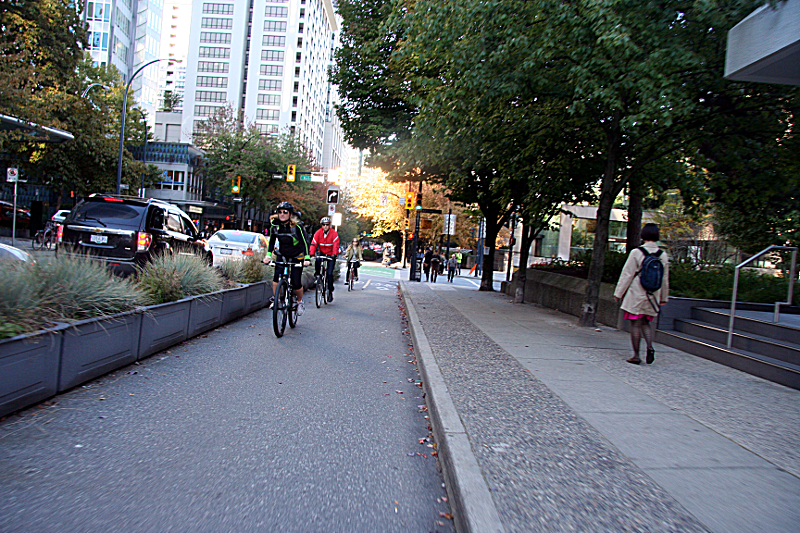
Planters in Vancouver, by Michael Andersen, used with permission.
The new framework builds on a Renewable City action plan from 2015 that called for a complete streets approach, and a Greenest City action plan from 2012. It comes as the city moves to address anticipated effects of climate change with an integrated rainwater management plan that leans heavily on best practices in street design for its goal of capturing 90 percent of stormwater runoff.
“We are trying to look at streets holistically, bringing land use, green infrastructure, public space and transportation together as seamlessly as possible,” said Rich Carmona, a senior Complete Streets planning engineer with the City of Vancouver. As the city begins to rethink its busiest corridors in dense areas, he added, “We need to show more comprehensive benefits.”
Green paint plus greenspace equals calmer travel
During the current decade, Vancouver has become the clear North American leader in bicycle transportation through dramatic steps to expand the city’s “all ages and abilities” cycling network — or triple A in local parlance. Not only did the city complete a downtown grid of protected bike lanes, in 2014 Vancouver became the first on the continent to build a “protected intersection” for people on bikes.
The confluence of Burrard Street and Cornwall Avenue at the south end of the Burrard Bridge was an auto-scape of swooping lanes for high-speed vehicle turns that was a terror for people on foot or bicycle. Traversing the intersection on foot required crossing 15 lanes of traffic at five different locations. The new design created a more conventional T intersection, reducing the pedestrian crossings to two, and added green paint and signals to create safer turns and crossing for the intersecting protected bike lanes.
“Part of calming that intersection, beyond normalizing the turning space, was adding 120 street trees,” said Dale Bracewell, manager of transportation planning for the City of Vancouver.
The city’s planners took lessons from that experience to the north end of the Burrard bridge at the intersection with Pacific Street, a busy bike route that had the second highest collision rate in the city. In building the protected intersection there recently, they not only added safer, separated routes for walking and biking, they also designed around a well-established cypress tree and planted 60 others trees there and along adjacent blocks.
(Note: This post and this NACTO presentation feature some before and after photos of both intersections. Both pieces also feature the video below, which shows through inset video how the streets looked before Vancouver made all these improvements.)
Storming into green infrastructure
While Portland is the acknowledged leader in green stormwater infrastructure, Vancouver is making a strong bid. In response to a mandate from the provincial government, Vancouver in 2016 adopted an integrated rainwater plan that seeks to capture and clean 90 percent of stormwater as close to where it falls as possible. The Complete Streets framework adopted last year, which calls for integrating green infrastructure with plans to rebuild streets to make them calmer and safer for all, was “one of our early implementation measures,” said Cameron Owen, the city’s green infrastructure planner.
“We want to make it so that every time we build a street or laneway (alley), add a bike lane or traffic calming,” Owen added, “we look for the opportunity to put in a rain garden, tree trench or structural soils that collect water and support tree growth.”
Construction and planting of an early example, at 63rd Avenue and Yukon Street, wrapped up this spring. In conjunction with an adjacent development project in the high-growth Cambie corridor, the city is carving a triangular mini-park out of the wide, paved right-of-way. Along with a new sidewalk and bikeway, the park space includes new street trees, benches, a water fountain, and rain gardens to collect run-off from adjoining streets.
“Beyond water volume and quality, we also are trying to reduce the urban heat island effect,” Owen said, describing the tendency of paved and built-over areas to disrupt weather patterns so that summers are hotter and drier than normal. “To do that we need to reduce impervious surfaces and boost the tree canopy.”
The city has an ambitious goal to promote that canopy by planting 150,000 trees. The rub, however, is that this needs to happen even as the city grows. “In really urban areas we don’t have room for large swales and rain gardens, so we have to do subsurface treatments underneath that absorb and hold water to support the urban forest,” Owen said.
The city is applying that strategy in creating the 10th Ave. bikeway, converting a parking strip into a protected lane serving one of the busiest cycling routes connecting destinations such as Vancouver General Hospital. “In order to support large street trees we are putting perforated pipe and subsurface storage under the bikeway,” Owen said. “This will provide a source of water and expand the rooting zone so they can grow to full size and maintain better health. When trees are in a little box by the side of the road it’s amazing when they grow at all.”
")
Cycling the Seawall in Olympic Village by Paul Krueger used under CC BY 2.0
From healthy trees to healthy streets
Recent research in Vancouver indicates that streets that support healthier trees can also boost the health of human beings and the earth’s climate. In 2012 the city began work on transforming the east-west Comox-Helmcken corridor through the densely settled West End into a “triple A” greenway. The $5 million, 1.6-mile project adds corner bulges and diverters to slow traffic — and provide gardening space — along with trees and street furniture and mini-park spaces that also serve a stormwater function.
In 2016, two studies of the corridor, including one at the University of British Columbia, found that “improved access to walking, cycling and opportunities for local connection” were associated with a 16 percent increase in residents’ daily exercise and a small but measurable drop in days of poor mental and physical health. In addition, researchers saw a rise in cycling trips and a drop in auto trips, with an associated decline in vehicle emissions.
“For the little bit of money that they spent, they got multiples of positive impact,” said researcher Dr. Lawrence Frank, professor in sustainable transport and director of the Health and Community Design Lab at UBC. He noted that the UBC study compared results with a control group of residents who also lived in the dense area but more than 300 meters from the corridor. “Even in an urban environment where many people walk, when it became more inviting and possible for people to be active and outside, we saw physical activity go up and emissions down.”
Removing cars from the equation
The vast majority of efforts to reallocate the street right-of-way and make it greener and more complete come down to maintaining plenty of space for cars while slowing them down. But what if cars aren’t part of the mix? Just such a scenario is unfolding in Vancouver with the design of the Arbutus greenway.
The Arbutus corridor is an opportunity to reimagine a decommissioned rail line, acquired in 2016, as a green transportation corridor.

The Arbutus corridor is an opportunity to reimagine a decommissioned rail line, acquired in 2016, as a green transportation corridor — with a series of gardens, swales and other green infrastructure alongside walking and biking trails and a streetcar running on rails through the grass. The one mode it won’t have is cars. It runs 9 km (5.6 miles) from South False Creek near the Granville Street Bridge to the Fraser River, near the Arthur Laing Bridge. The design proposal, based on feedback from a long public engagement process was unveiled in late April. It envisions eight “character zones”, from a “Harvest Table” segment planted with edibles to a pastoral “Woodland Bend” and a more urban-feeling “Electric Alley,” ranging in length from a third to one and a quarter miles. The design will be vetted and refined over the next several months before funding begins to be identified and construction phased.
“This is an exciting time,” Bracewell said. “It will be very interesting to see where slowing and making complete streets, incorporating green stormwater infrastructure and growing the tree canopy intersect, and how they are funded in our next capital plan.”
Portland and Seattle got the jump on their Canadian counterpart in adopting goals for complete streets and stormwater infrastructure. But look for Vancouver to leapfrog ahead by merging ambitious stormwater and tree canopy goals with deep experience in greenways and all-ages-and-abilities design.
Terry L Nichols
I have sent several letters asking when we could expect our cul-de-sac to be resurfaced & have received no reply. I think 2005 was the last time it was repaved and the surface has virtually disintegrated into a rough dirt road. Admittedly most of the roads here don’t look this bad, but quite a few do. I would really like to know when our neighbor-hood would like nice again, so please don’t ignore me again. Thank you.
Terry Nichols, [redacted]
Serena Larkin
Hi Terry. I think you mean to send your request to your local representative. Sightline does not manage street repaving.
Take care,
Serena
Editorial Director, Sightline Institute