Vancouver is perceived throughout North America as a vanguard in refocusing growth in the urban core. But the reality is that for decades, there has been a tragic mismatch between where people want to live—Vancouver proper—and where the region has built most new housing—the surrounding suburbs.
Metro Vancouver is currently updating its regional growth strategy, the official road map for how the region will grow through 2050. But while lifting bans on townhomes and small apartments in detached-house neighborhoods has widespread support across the city of Vancouver, a recently released draft plan calls for the city of Vancouver to be the slowest-growing part of the Metro Vancouver region over the next 30 years.
If things play out as envisioned in this draft, the result will be even higher home prices and more exclusion in Vancouver. Elsewhere in the region, it will mean longer commutes, more climate pollution, and accelerating loss of farms and forests.
The Metro Vancouver 2050 plan is a critical opportunity to create a better future for the region by reversing that trend and reining in a half century of sprawl. Allowing growth in the city of Vancouver instead of pushing it away is the key to a more affordable, low-carbon region.
The Past 25 Years
Both Vancouver’s image of itself and the one projected throughout Cascadia is of gleaming glass condos above seawall bike paths. Douglas Coupland’s 2000 book title, City of Glass, captures this idea. And when Vancouver Sun columnist Douglas Todd writes that, “a strong case has been made that the ‘condofication’ of Metro Vancouver has done more than anything else to define this West Coast city,” for many of us, the image conjured is that familiar view of downtown condos silhouetted by the mountains behind them.
This idea that Vancouver’s condo towers on the downtown peninsula define the city is common but misleading.
The vast and increasing majority of homebuilding in Metro Vancouver occurs far from downtown and outside of Vancouver itself. If this seems surprising or implausible, it will be useful to review some basic data about where the metro region has grown in recent years.
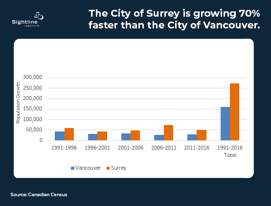
The city of Vancouver had 631,000 people over 44 square miles at the time of the 2016 census, while Metro Vancouver had about 2.5 million over nearly 1,160 square miles. And while housing and development discussions often focus on Vancouver, its prominence within this region is declining as other cities outpace its growth. The city of Surrey, for example—a suburb southeast of the Fraser River—added nearly twice as many residents as Vancouver since 1991.
 In fact, fewer than one in five new residents in the region have moved to the city of Vancouver at all, let alone to seaside condo towers, since 1991.
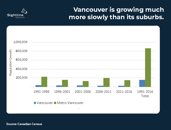 The city of Vancouver’s share of regional population growth has steadily declined as restrictive, detached-house zoning has blocked homebuilding in established neighborhoods, while the region has sprawled further into the Fraser Delta and up the Coast Mountains.
So when we discuss “development” in Metro Vancouver, we should imagine a new townhouse in South Surrey as much as the oft-discussed condo tower in the city of Vancouver.
Pulling up the Drawbridge: The Plan for Sprawl
The city of Vancouver took on 18.6% of regional population growth from 1991-2011. In the recent 2040 regional plan, Vancouver’s planned growth share was reduced to just 14% over the period from 2011-2041. As in the earlier period, the vast majority of both new housing and population increase was set to occur elsewhere.
 Unlike the 2040 plan, the draft 2050 plan does not provide municipality-specific projections. Instead, only “sub-regional” projections are provided, so that the city of Vancouver has been grouped with New Westminster and Burnaby as part of the “Burrard Peninsula” (Vancouver, Burnaby, New Westminster, and UBC).
The 2050 plan explains that this change provides “flexibility” and “resiliency to changes.” But removing the municipality-specific projections also eliminates a key accountability mechanism. In the numbers provided in the draft, for example, the “Burrard Peninsula” projection masks the city of Vancouver’s relatively slow growth by combining it with faster-growing municipalities—in particular, Burnaby.
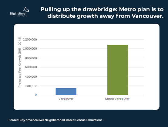
Accounting for this change in data presentation, I have included a bar for Vancouver below, assuming that Vancouver’s 2050 growth will be proportionate to its share of the Burrard Peninsula’s projected growth in the 2040 plan:
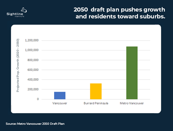 As with the 2040 plan, the new draft plan locates around 85% of new housing far from downtown Vancouver, so that most residents will have to drive or take transit long distances if they want to visit or work in the region’s epicenter of entertainment and employment.
The latest data from Statistics Canada show growth largely in line with the 2040 plan so far. Vancouver did make room for two percent more people than projected from 2011-2020, as did New Westminster and the city of North Vancouver, while Coquitlam, Port Moody, and Port Coquitlam all missed their housing targets, despite the recent completion of the Evergreen elevated rail line that serves Port Moody and Coquitlam.
A recent provincial economic plan also calls for continuing and accelerating sprawl, euphemistically called “distributed growth” in the plan. The provincial plan calls for “new policies that incent and encourage distributed growth in suburban and regional economies,” citing concerns about congestion and affordability in Vancouver proper. But because housing scarcity contributes to unaffordability, distributing growth away from Vancouver will make Vancouver even less affordable than it already is. And distributing jobs and homes over larger areas will increase commute times and congestion, not reduce them.
Some pushback against this direction is already evident. Sightline recently explored how housing unaffordability has led to calls for the province to get involved and override exclusionary local zoning, and a government-appointed expert’s panel on housing affordability has criticized demographic estimates that underestimate housing needs.
But People Really Want to Live in Vancouver
How do we know that a lot of people would rather live in Vancouver than its suburbs? One measure of desirability is price. People are clearly willing to pay a premium for the same house or apartment in Vancouver relative to almost anywhere else in the region. People must value something about Vancouver.
For many people, it makes sense to choose Vancouver and the neighboring University of British Columbia lands, which boasts two large research universities plus Emily Carr and Langara, three large hospitals, and about one-third of all the jobs in the region.
The city of Vancouver is amenity-rich as well, with most of the best beaches, a beautiful sea wall with a multi-use path along the Pacific Ocean, and Stanley Park. Restaurants and nightlife are also big draws for new and established residents alike.
Vancouver Households Save $3,000/Year on Cars
Aside from the amenities, beaches, nightlife, and jobs proximity, many people may choose to live in Vancouver to save money on cars.
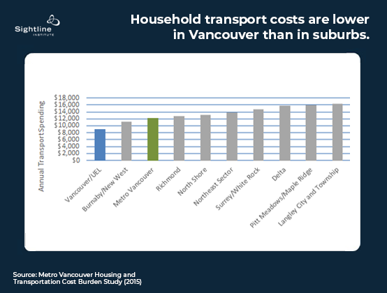
A 2015 study by Metro Vancouver staff found that the average Vancouver household saves about $3,300 on transportation costs compared to the regional average. About half of that difference can be explained by smaller average household sizes in Vancouver, but even adjusting for that difference, there’s a large transportation savings from living in Vancouver. The same study, meanwhile, found that Vancouver’s household housing costs were $2,484 higher than the regional average.
It’s a tradeoff. Some households opt to spend more on housing and save on transportation costs, while others buy a car, or a second car, and move to the suburbs to save on housing.
This tradeoff is more stark when comparing Vancouver to individual car-dependent suburbs. In the 150,000 person suburb of Langley, which is situated a little more than 30 miles southeast of downtown Vancouver, household transportation spending was a whopping $6,780 higher than in Vancouver. Housing costs $4,140 more in Vancouver, but that still doesn’t offset the higher cost of transportation in Langley.
If the region built new housing in inner-ring neighborhoods on Vancouver’s wealthy west side at the same rate as it has in the outlying suburbs, for example, tens of thousands more people would have the opportunity to live in a place that enables lower total household expenses because cars are optional.
 In addition to the household costs imposed by sprawl, of course, the climate impacts are also severe. Over 40 percent of BC’s greenhouse gas emissions are from transport, and the majority of that is from road transportation.
Most of the 2050 Draft Plan’s goals address climate, including “create a compact urban area,” “protect the environment,” and “support sustainable transportation choices.” But the plan itself contradicts these goals by pushing growth away from Vancouver and into the more car-dependent parts of the region.
The city of Vancouver not only has the lowest share of trips by car in the region (except for the neighboring university lands) but the growth in commuters in Vancouver since 1996 has been mostly transit riders, walkers, and cyclists. In Surrey, Langley, and the rest of the region, by contrast, the vast majority of the increase in commuters has been drivers.
A regional plan that adhered to its own stated climate goals would look very different from the current draft. That plan would focus growth in walkable, transit-adjacent areas near downtown Vancouver, where people can more easily save money and reduce carbon pollution by getting around without a car.
Declining neighborhoods
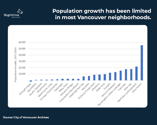
Even as the city of Vancouver has been growing more slowly than the region as a whole, most Vancouver neighborhoods have hardly grown at all. Thanks to the work of Abundant Housing’s Stuart Smith, we now have neighborhood-level population figures for Vancouver going back to 1971. These figures tell a story of uneven development: huge growth in the redeveloped parts of the downtown waterfront, moderate growth in the new towers at Joyce-Collingwood SkyTrain station, and a sprinkling of new mid-rise housing in Mount Pleasant and a handful of other neighborhoods.
Meanwhile, ten of Vancouver’s 22 neighborhoods added fewer than 2,500 people over 45 years, with one of the city’s wealthiest areas, Shaughnessy, actually losing 2,000 residents amid nearly a half century of regional growth.
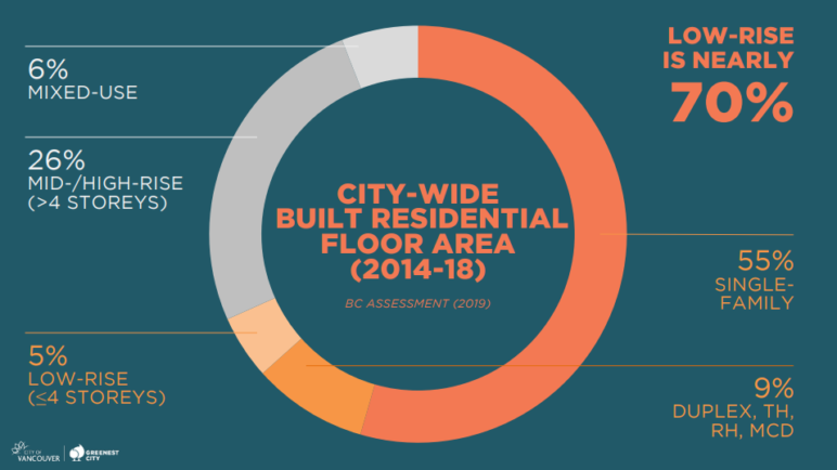
 The result of locking so much of the city into mid-20th century densities is that the primary form of construction in Vancouver is not rental apartments or even condos. Most of our construction labor adds nothing to the supply of homes. Instead, we are tearing down older detached houses and building new ones, as shown by this city of Vancouver graphic:
 Let’s Try Vancouverism
It’s easy to imagine an alternative timeline in which we preserved more Delta farmland and Coquitlam hillsides, gradually building up Kerrisdale and Point Grey with mid-rise apartments and towers, much like Vancouver’s celebrated West End grew up in the 1950’s and 1960’s.
Picture a dense city by the beach with a glorious hinterland of farms and mountains, closer to the city than they are today, all connected by pleasant walkways, rolling paths, and rapid transit.
This idyllic style of urban planning—encouraging density in livable, central neighborhoods—even has a convenient, home-grown name: Vancouverism.
When people are given the opportunity to live in walkable, central neighborhoods, they leap at the chance. It’s now time to open up that opportunity to hundreds of thousands of new residents.
As cities up and down the West Coast grapple with stifling housing costs and scramble to increase housing availability in central neighborhoods, Vancouver is often cited as a relative success story. But despite the allure of this vision, even Vancouver hasn’t tried Vancouverism. Yet.
Metro Vancouver’s 2050 plan is our next best chance to finally make the reality match the marketing materials and build centrally-located homes in beautiful, walkable neighborhoods.
Metro Vancouver is inviting comments on the draft plan until November 26, 2021.
