It’s been a big week for walkability, with two steps forward for online mapping of pedestrian-friendly neighborhoods:
- Walk Score—which has become North America’s most prevalent gauge of neighborhood walkability—is going open source, so that anyone can see how their rankings work and (just as importantly) suggest improvements. This has a real potential to lead to some major breakthroughs, since it will let academics and others add their own insights and ideas to the Walk Score algorithm. The Walk Score gurus also are working to improve their measurements of walkability by adding information on transit service, and are aiming to incorporate estimates of neighborhood greenhouse gas emissions and transportation costs to make the benefits of walkability even clearer. Great stuff!
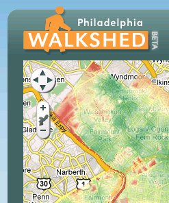
 A newly launched website called Walkshed offers a slightly different take on walkability, by letting users choose the amenities that are most important to them. Want to live within walking distance of grocery stores and transit, but don’t care about bars or clothing shops? Walkshed lets you find the neighborhoods that match your preferences. And it also uses a very clever method to incorporate barriers to walking—rivers, rail lines, or impassable highways—in calculating the walking distance between two points. The only problem for Northwesterners is that Walkshed is only available for Philadelphia…at least for now.
 A newly launched website called
 Ain’t technology grand?