Never content, the crew over at Walk Score is at it again. This time, they’ve handed over the keys by letting users provide on-the-street feedback about neighborhood walkability. With their new iPhone app (us Droid users will have to wait), you can mark neighborhood gems, identify problem spots, find neighborhood walking tours, and see what other users have added.
This is a huge step forward, adding qualitative real-world knowledge to Walk Score’s already-excellent quantitative mapping system. Google Maps doesn’t know when construction blocks a side walk (and Apple’s new mapping system can use all the help it can get). By letting local experts with feet on the pavement provide input these maps are going to get way more useful.
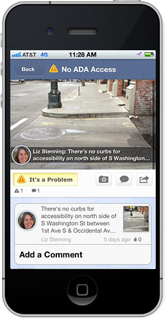
Locally, Feet First, International Sustainability Institute, and the Alliance for Pioneer Square used the new app to conduct a “walk audit” of Seattle’ Pioneer Square neighborhood. The audit results are a nice example of how feedback from individuals can enhance the Walk Score platform.
These new tools are a real boon to Walk Score, and will make the tool even more useful to transportation planners and wonks across the region. Crowd-sourcing problem areas and local success stories let’s us know what we need to fix and how best to do it. Kudos, Walk Score.

I had given them feedback about how basically every location in Palm Desert is randomly distributed in Google Maps; up to MILES out of position. They don’t count COLLEGES. They don’t count INDOOR MALLS. And every location, as shown on their map, is up to a mile or more further away from my home than it is. Like someone threw a virtual grenade on top of my neighborhood and blew all the restaurants, stores, schools, services, etc. away from it. 100 yards from my driveway to ‘Trader Joe’s’, but they think I’m close to ‘vitamin world’, and I have no idea where that is.
The ‘web app’ is absolutely useless. The problem isn’t that features aren’t there. They are on the map – MILES out of position. There’s no way to ‘vote’ the pointer for their locations onto a more accurate position.
Their response when I had used their previous ‘get satisfaction’ form? Make MY HOUSE’s individual score ‘Very Walkable’, while houses next door, on either side of me have ‘Somewhat Walkable’ scores. VERY scientific. Shows a real dedication to doing things ‘right’, IMHO. NOT.
Walk Score has the right idea, but PEER-REVIEWED, PUBLISHED scientific research shows it is flawed. https://flowalking.com/2013/05/what-does-walk-score-mean-the-surprising-results-of-scientific-research/