Coal and oil companies hope to use rail cars to ship massive quantities of their product through the Pacific Northwest. To gauge the impact of these plans, Sightline is analyzing public at-grade rail crossings from Sandpoint, Idaho to Cherry Point, Washington.
We’ve already looked at northern Idaho and Spokane County. In this installment, we examine eastern Washington.
Traveling from fossil fuel deposits in the interior of North America to port terminals and refineries on the coast, coal and oil trains will close streets and disrupt vehicle traffic for hours each day.
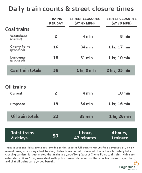
Please note that the crossings we analyze here are by no means comprehensive. Rather, we selected several representative communities where coal and oil trains will travel. In each of these places they will shut down streets and roads every single day from 1 hour and 47 minutes to 4 hours, on average.
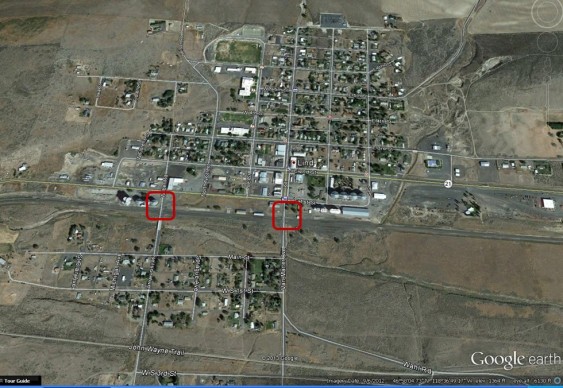
After traversing Idaho and Spokane County, loaded trains will pass through Lincoln County, including the three at-grade rail crossings in Sprague.
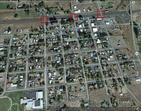
Sprague, WA (Lincoln County): B Street, D Street, and F Street
At present, 37 trains pass through Sprague each day, which means that coal trains would roughly double freight rail volumes there, and oil trains would represent an additional huge increase. Each crossing is lightly trafficked, but protected by a crossing gate.
From Sprague, trains continue southwest into Adams County where they will close streets in Ritzville, among other places:
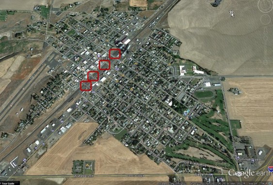
Ritzville, WA (Adams County): Columbia, Division, Adams, and Jefferson Streets
The center of Ritzville contains four BNSF at-grade crossings, each one protected only by flashing lights. The highest average vehicle traffic is at the Adams Street crossing, where 1,900 vehicles pass over the tracks that are currently occupied by 35 trains per day. The Ritzville Airport is visible to the southwest of town, and to the northeast the two-building complex of Ritzville Grade School and Ritzville High School can be seen alongside the schools’ athletic field.
Leaving Ritzville, coal and oil trains pass through the small town of Lind:
 `
`Lind, WA (Adams County): Van Marter Avenue and Wilbur Road
Although each crossing sees only a few hundred vehicles each day, they are protected by gates. At present, 35 trains pass through the town daily. Lind High School buildings and its athletic facilities are visible on the north side of the town and tracks.
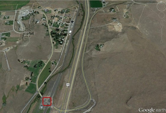
Further south, the BNSF mainline reaches Hatton, population 102:
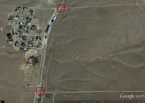
Hatton, WA (Adams County): Hampton Road and Hatton/Garrison Road
The southern crossing, at Hatton/Garrison Road, is protected by gates, but at Hampton Road, to the north, the only warning to motorists is a road sign crossbuck. On an average day, 36 trains pass through these crossings, which means that fossil fuel-bearing trainloads would increase freight rail volumes by more than 150 percent here, as elsewhere.
Continuing south into Franklin County, coal and oil trains reach the town of Connell:
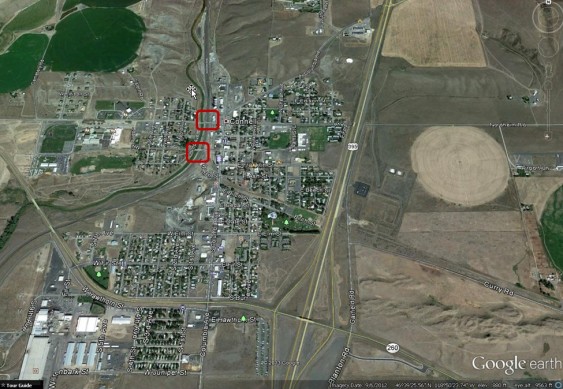
Connell, WA (Franklin County: Clark Street and East Adams Street
Both at-grade crossings are protected by gates from the 37 trains that now travel through the town each day. The rain lines divide the town in two. To the east are athletic fields, and to the west is a school complex, including (clockwise from the North) Connell Elementary School, Robert Olds Junior High, and Connell High School.
Further south in Franklin County is Mesa:
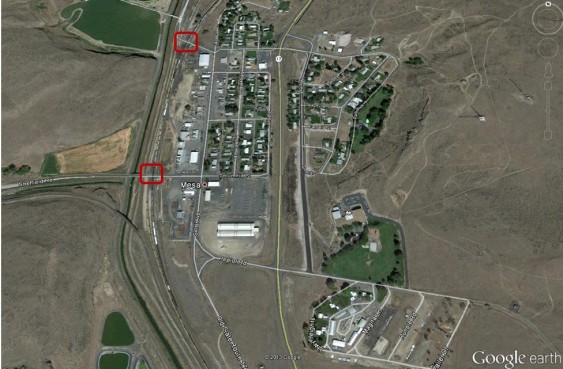
Mesa, WA (Franklin County): Manton Way and Sheffield Road
The town of Mesa is flanked by BNSF grade crossings, one at Manton Way to the north and one at Sheffield Road to the south. Each is protected by gates and each see 37 trains passing by daily. Visible to the southeast of town is Mesa Elementary School.
In July 2012, a coal train derailed in Mesa, blocking access on Manton Way, requiring cleanup and repairs by BNSF. Images of the derailed and destroyed rails cars can be seen here.
Continuing south in Franklin County, trains comes to Eltopia:
Eltopia, WA (Franklin County): Eltopia Road West
South of town, Eltopia’s at-grade crossing is signed with flashing lights. Currently, 37 trains pass through daily.
Continuing south, the BNSF mainline reaches a sizable urban center, Pasco:
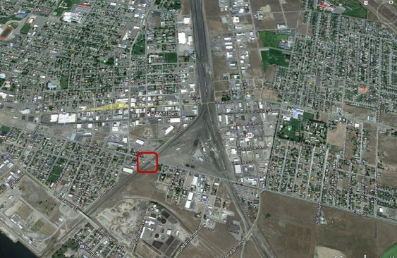
Pasco, WA (Franklin County); A Street
Pasco contains multiple BNSF at-grade crossings, including several that support 29 trains per day or more. The most active crossing is at A Street, shown above, where 40 trains travel per day and average vehicle traffic is 3,500 per day. A Street is protected by gates, but several other crossings with heavy train traffic in Pasco are flagged only by simple road signs with crossbucks. One such crossing is at South 10th Avenue, where 27 trains and 5,600 vehicles pass through on an average day. Pasco Senior High School and its baseball field are visible in the northwest corner of the image.
Shortly after A Street, the tracks cross the Columbia River en route to Kennewick:
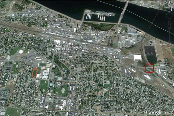
Kennewick, WA (Benton County): Third Avenue East
Two BNSF at-grade crossings lie within Kennewick,including one at Third Avenue East (marked above) that is marked by flashing lights to protect vehicles from the 32 trains that cross daily. Kennewick High School and its athletic fields are visible to the west of the crossing.
Coal and oil trains proceed southeast from Kennewick:
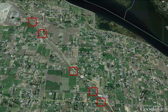
Benton County, WA: E. Bernath Road, E. 25th Avenue, Perkins Road, Haney Road, and Bowles Road
Southeast from Kennewick lie seven BNSF at-grade crossings, five of which are depicted above. Each crossing handles 32 trains per day and is protected by gates.
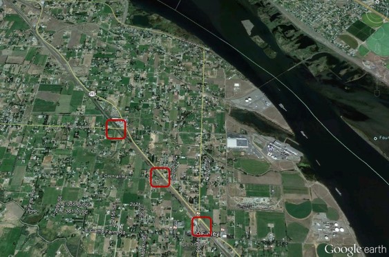
Benton County, WA: Cochran Road and Finley Road
The remaining two BNSF grade crossings southeast of Kennewick are at Cochran and Finley Roads. (The Bowles Road crossing to the north is shown again and marked.) The crossing at Finley has the highest traffic volume of the seven, with 1,943 vehicles per day. Nearby the Finley crossing are several “children crossing” icons indicating school buildings, including River View High School and Finley Middle School to the west of the tracks.
From Finley Road, the BNSF mainline continues along the Columbia River to the southeast, then proceeds to the west. In our next installment, we will examine street closures in these communities along the Columbia.
You can enlarge the images by clicking on them.
Click here for detailed notes on sources and methodology behind this series.
John Abbotts is a former Sightline research consultant who occasionally submits material that Sightline staff turn into blog posts. Thanks to Devin Porter of Goodmeasures.biz for designing the table.
Have photos of a crossing featured in this series? Share them in our “Wrong Side of the Tracks” Flickr pool.

It’s good to publish these aerial views of at-grade crossings through small & mid-size towns. Continue compiling aerial views along the routes. Dub-in full-length trains to this perspective view to further dramatize the image of impact.
Longview has a choice: West Hayden Island will NOT become a marine terminal as the Port of Portland proposes as it’s a severe hindrance to all Columbia River railroad crossing operations. Even BNSF operations are degraded.
Therefore, Longview is the next logical port for the Panamax Class of vessel, mostly to off-load Asian automobiles with Panamax. Longview can export coal, or import Asian cars at the closed aluminum smelting plant site now being cleaned up. Many of the Asian cars will be hybrid and electric.
Hello Wells,
Thank you for your comment. We have been working with Google Earth images, and thus far have depended on random chance for the image to show a real train. In the collection above, if one clicks on the Mesa image, the larger image that opens makes clear that rail cars extend from south of the crossings to the north end of the image. However, I cannot tell you for sure that all the cars are from one train, vs. some cars just being stored in the yard.
But my guess is that for that length of a line of rail cars, much of it is likely one train.
There should be images of real trains that also appeared in some of our earlier posts. If my recollection is correct, some of the images that we plan to post from Western WA show rail cars that appear to be blocking traffic. Please stay tuned,and thanks again for your interest.
Don’t coal cars have hard material tops? Are you not way overblowing this issue?
ellen
Hello Ellen,
Thank you for your comment. We figure that if one person asks a question, there may be others who have similar thoughts, but are too bashful or busy to ask.
Perhaps the best way to address your questions is by referring to today’s post on Coal Dust from Eric and Professor Emerita Baker, at
https://sightline.wpenginepowered.com/2014/02/20/dust-up/
Their post alone contains two photos of filled, open coal cars.
In addition, a commenter on another of our posts reported that covers on coal cars may actually be a hazard, because the coal dust in a confined space may catch fire and/or explode. Those comments appear about two-thirds of the way down the page, at https://sightline.wpenginepowered.com/2013/12/03/how-coal-and-oil-trains-will-block-traffic-snohomish-county/
In addition, a search on the Daily’s web pages for “coal train images” found the following results, at:
https://sightline.wpenginepowered.com/2012/06/27/why-seattles-freight-interests-should-worry-about-coal-exports/coal-train-seattle/
and: https://sightline.wpenginepowered.com/2011/09/14/an-alternative-to-coal/coal-trains-paul-anderson-with-permission/
and: https://sightline.wpenginepowered.com/2010/12/10/cooooooal-train/
and: https://sightline.wpenginepowered.com/2013/01/18/who-pays-for-freight-railway-upgrades/coal-train-photo-credit-jesse-varner/
As Sightline has also reported, in the Pacific Northwest, “unit trains,” carrying rail cars with only a single commodity, such as oil or coal, may be taking the same routes to refineries and/or export terminals. And oil trains emit vapors, not dusts. But they do explode violently, see: https://sightline.wpenginepowered.com/2013/07/07/huge-oil-train-explosion/
Again, Ellen, thanks for your questions. I hope this material provides a detailed answer, without going overboard.