Heading for the mountains for some clean air?
Maybe you should turn back. The mountain air near the Pacific Northwest’s biggest cities may be worse than the air in those cities—at least in terms of round-the-clock levels of one pollutant, ozone. See animation.
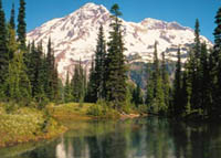
Some of the worst day-long ozone levels in local air in the Pacific NW are at—of all places—Paradise, in Mount Rainier National Park, even occasionally exceeding the health-based ozone standard. During the summer of 2003, Paradise was on the short list of three sites in Washington that exceeded the standard.
During the summer of 2004, the standard wasn’t exceeded at Paradise, although ozone levels have been chronically elevated and soared briefly to 110 ppb at Tahoma Woods (near Ashford) on July 24—one of the highest levels measured in the state. But evidence suggests that the effects may still be harmful to plant life.
What is ozone?
Ground-level ozone—the main component of smog—is a product of chemical reactions in the atmosphere between, among other things, sunlight and nitrogen oxides (NOx) that are released from cars and factories. In the summer, ozone cooks up in the atmosphere downwind from the sources of the original pollutants, resulting in highest concentrations in suburban and rural areas. It can damage plants and ecosystems, and can cause a variety of health problems even at low levels. (See EPA page on ozone.)
How can air be worse at Mt. Rainier?
Mount Rainier and the surrounding section of the Cascade Range is often downwind from the Puget Sound population center. And, by a fluke of atmospheric chemistry, downwind locations bear the brunt of ozone pollution.
While other air pollutants such as particulates and carbon monoxide are less concentrated outside of cities, ozone grows more abundant. During the day, NOx produces ozone in abundance, boosting suburban and rural concentrations all day. When the sun goes down, however, NOx reverses course and destroys ozone. But ozone that’s carried up the foothills toward the Cascade heights is left by nightfall in places where there is little NOx in the air. So while ozone levels drop to near zero in urban and suburban areas, the ozone remains undiminished in remote areas.
To help you visualize how NOx travels to Mt. Rainier, researchers at Washington State University Laboratory for Atmospheric Research and the University of Washington have developed an air quality forecasting system that illustrates the transport of NOx from the urban corridor to Mt. Rainier National Park. This Flash animation is based on this system.
It shows how winds send this cloud of pollution toward the Cascades, often engulfing Mount Rainier. The plume from the Centralia coal-fired power plant stands out to the south of the main pollution cloud.
What are the effects of ozone pollution at Mt. Rainier?
Ozone concentrations at Paradise, as throughout the Pacific Northwest, only rarely rise above the health-based standard set by the Environmental Protection Agency. But even the concentrations routinely measured in Mount Rainier National Park may be enough to stunt plant growth. In fact, evidence suggests that a similar rural-urban pattern of ozone pollution around greater New York has led to significantly decreased plant growth in the surrounding rural lands than in heavily polluted New York City.
Northwest plants that are especially sensitive to ozone pollution include red alder, ponderosa pine, and quaking aspen. Ozone is one of the most phytotoxic air pollutants and causes considerable damage to vegetation throughout the world. The effects range from visible injury to the leaves and needles of deciduous trees and conifers to premature leaf loss, reduced photosynthesis, and reduced growth.
Ozone also makes plants more susceptible to disease, pests, and environmental stresses, and interferes with the ability of plants to produce and store food. Ozone effects on trees are believed to add up over many years so that whole forests or ecosystems can be affected.
What can we do?
The NOx in Northwest cities mostly comes from cars. Industrial facilities, such as the Centralia coal-fired power plant, emit most remaining NOx pollution. Each day, cars in the central Puget Sound counties collectively drive over 79 million miles, as tracked in “Vehicle Miles Traveled” under Puget Sound Regional Council’s “Transportation Trends.” Industrial facilities, such as the Centralia coal-fired power plant, emit most remaining nitrogen pollution.
Cleaner-burning vehicles and factories, combined with more-compact, transit-friendly development patterns, can help safeguard wild lands from the ozone cloud that currently shrouds them each summer.
For information on reducing vehicle use through land-use and transportation solutions, see:
Sightline’s recommendations for compact communities
The Puget Sound Clean Air Agency’s page on smog
More information about ozone and air quality at Mt. Rainier
Seattle P-I article: Danger in the air at Mt. Rainier
American Lung Association fact sheet on human health impacts
American Lung Association fact sheet on ozone
Sources
1. Sarah Brace and David Peterson, “Spatial Patterns of Tropospheric Ozone in the Mount Rainier Region of the Cascade Mountains, USA,” Atmospheric Environment, pp3629-3637, 1998.
2. Jillian W. Gregg et al., “Urbanization Effects on Tree Growth in the Vicinity of New York City,” Nature, July 10, 2003.
3. Puget Sound Regional Council, Vehicle Miles Traveled, under “Transportation Trends” in the Puget Sounds Trends Index.
4. Department of Ecology’s ozone readings for Paradise and other spots.
Note about air-quality forecasting system: This animation depicts the transport of NOx emissions from the urban corridor to Mt. Rainier on a typical summer day. NOx is one component of smog which includes ozone and particulates. To view a similar daily animation for ozone, go to the EPA AIRNow website (summer only). The animation was created by researchers at the Washington State University (WSU) Laboratory for Atmospheric Research, in collaboration with meteorologists at University of Washington (UW) and others to predict pollutant levels, hourly, for areas across the Pacific Northwest.


