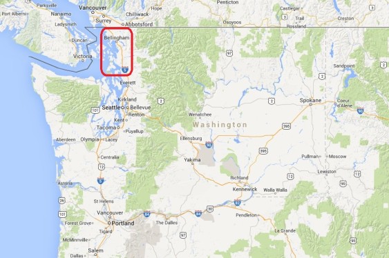
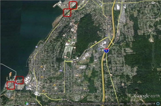
To inform debate over coal exports and oil shipments, Sightline is analyzing public at-grade rail crossings from Sandpoint, Idaho to Cherry Point, Washington.
If fossil fuel companies succeed in shipping the volumes of fuel they have planned, they will—by sheer physical necessity—disrupt vehicle and rail traffic all along the rail route. In our final chapter of the series, we examine the effects in Skagit and Whatcom Counties.
Coal and oil trains—loaded in the interior of North America and bound for the coast—would close off streets for hours each day.
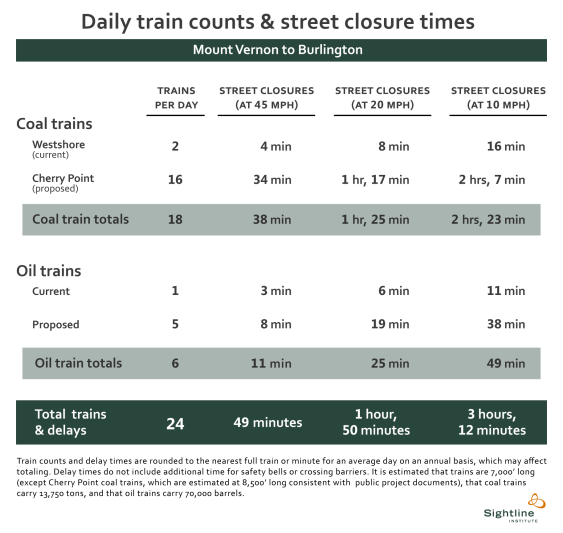

The list of cities and crossings we analyze here is not comprehensive. Rather, we depict several representative locations in northwest Washington. South of the junction in Burlington that leads to the Anacortes refineries, we estimate that coal and oil trains would close streets by an average of between 49 minutes and 1 hour and 50 minutes, each day. North of the junction, streets would close 43 minutes to 1 hour and 37 minutes daily. At the slower speeds that are typical of urban areas, fossil fuel trains could shut down streets for roughly 3 hours a day, on average.
Note that these street closures would be in addition to street closures from current trains.
In our previous installment, we examined street-rail interfaces in Snohomish County. In this chapter we look at the next leg of the journey as trains roll into Skagit County and reach the city of Mount Vernon.
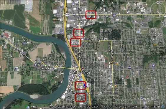
Mount Vernon, WA (Skagit County): Section Street, Kincaid Street, Fir Street, 4th Street, and State Route 538
Mount Vernon contains multiple BNSF public grade crossings, five of which are shown in this image. Each is protected by gates, and each currently sees only 12 trains on an average day, which means that new coal and oil trains would approximately triple rail volumes through town. The highest street traffic occurs at the State Route 538 crossing, the northernmost crossing in the image, with 26,000 average daily vehicles. (State Route 538 is also called College Avenue.)
The Skagit River runs to the west of the rail lines, the athletic oval near the town center shows the location of Mount Vernon High School, and the mortarboard icons in the northeast a branch of Washington State University and further east, Skagit Valley College.
Trains continue north, crossing the Skagit River and reaching the town of Burlington.
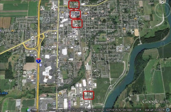
Burlington, WA (Skagit County): Pease Road, Greenleaf Street, Fairhaven Street, and Avon Avenue
There are multiple grade crossings in Burlington, including some along the east-west rail line that serves the oil refineries at Anacortes. In our analysis, however, we examine only the north-south BNSF mainline, which crosses four public streets. Each is protected by gates and each sees 12 trains passing by daily. The highest street traffic is at Avon Avenue, with 11,000 average daily vehicles.
In the middle of Burlington oil trains bound for the Tesoro or Shell refineries at Anacortes depart the mainline track. North of the Greenleaf Street crossing (third from top), we therefore predict slightly lower fossil fuel train volumes because these oil trains have peeled off.
The icon with an “M” to the west of the Pease Road (southernmost) crossing designates the Children’s Museum of Skagit County. The children crossing icons represent schools: the West View Elementary School to the west of the tracks, and the Lucille Umbarger Elementary School to the east of them. The book icon near the city center shows the Burlington County Library.
Beyond Burlington, trains pass through agricultural lands in the Skagit Valley, then take the winding beach-side route along Chuckanut Drive, and then reach the city of Bellingham.
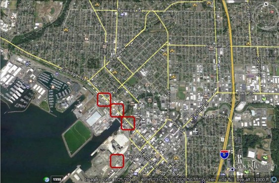
 Bellingham, WA (Whatcom County): Harris Avenue, Alk Fry Access Road, Beal Memorial Way, and Cornwall Street
Bellingham contains multiple BNSF public grade crossings, the first few lie near the city’s Fairhaven and South Hill neighborhoods. In Bellingham, 15 trains pass through each crossing daily. Harris Avenue (the southernmost crossing) leads to the Alaska ferry terminal and has the highest street traffic, at 3800 average daily vehicles. Cornwall Street (the northernmost crossing) is signed only by flashing lights; the other crossings are protected by gates.
The children crossing icon between the tracks and Interstate-5 designates the Happy Valley Elementary School. The mortarboard icons to the east of the tracks represent parts of Western Washington University, which lies up a hill from the rail line.
Further north in Bellingham, trains encounter additional street crossings.
 Bellingham, WA (Whatcom County): Laurel Street, Central Avenue, C Street, and F Street
As trains pass along Bellingham’s waterfront and round a corner near downtown, they reach four street crossings very near the city center. Only F Street (the northwest-most crossing) is protected by gates. It is the busiest crossing shown here, handling 5,600 vehicles on a typical day. Laurel and Central Avenues are marked by flashing lights, while the only warning at the C Street crossing is a stop sign. Fifteen trains pass through each crossing daily.
The gavel icon to the north of the crossings represents the Bellingham Municipal Court; the columned building icon just south of the Court represents the Bellingham City Hall. The children crossing icon to the west represents Columbia Elementary School; and the mortarboard in the northwest part of the image represents Bellingham Technical College. The Bellingham Marina lies just south of the rail lines.
Proceeding northwest from Bellingham, trains come to the community of Marietta-Alderwood.
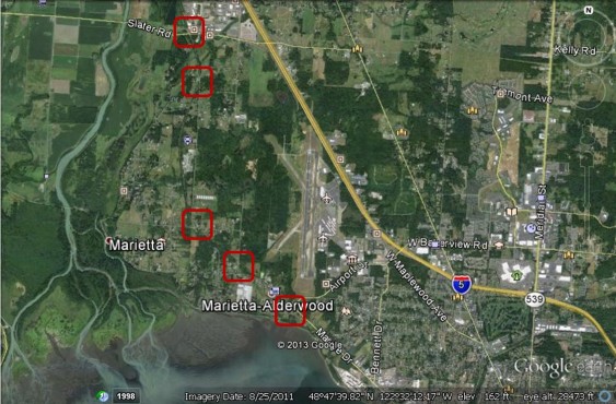 Marietta-Alderwood, WA (Whatcom County): Cliffside Drive, Wynn Road, Country Lane, Rural Avenue and Slater Road
Twelve trains pass through each of Marietta-Alderwood’s five gate-protected crossings on a daily basis. The highest street traffic is at Slater Road, with 5,000 average daily vehicles.
The children crossing icon to the east of the Cliffside Drive crossing is the Alderwood Elementary School. The Bellingham International Airport is visible just to the west of I-5.
Further north, trains comes to the town of Ferndale.
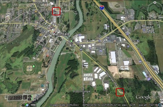 Ferndale, WA (Whatcom County): Hovander Road and Washington Street
Two BNSF public grade crossings lie in or near Ferndale. Each are protected by gates and each sees 12 trains daily. Street traffic is highest at Washington Street, with 3,500 average daily vehicles.
The golfer icon to the east of the Nooksack River indicates the Riverside Golf Course; the tree icon to the west of the river indicates Pioneer Park.
North of Ferndale, the small community of Custer sits alongside the tracks at a railway junction that provides access to the Cherry Point-area refineries owned by BP and Phillips66, as well as the planned Gateway Pacific coal terminal.
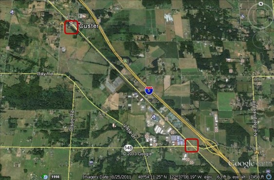 Custer, WA (Whatcom County): Grandview Road and Main Street
Custer is home to a pair of BNSF at-grade crossings, each protected by gates. Twelve trains currently pass through each daily, along with 3,200 vehicles at Grandview Road (the northern crossing), the busier of the two intersections.
A child crossing icon designates Custer Elementary School near the Main Street crossing (the southern crossing).
From Custer, Cherry Point-bound trains depart from the mainline, heading west on the “Custer Spur” before turning south.
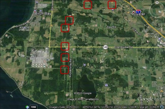 Cherry Point, WA (Whatcom County): Valleyview Road, Arnie Road, Kickerville Road, Bay Road, Grandview Road, Brown Road, and Aldergrove Road
The Cherry Point area is home to at least 7 BNSF public grade crossings, (listed above from east to west, and then south). Currently 4 trains pass through each crossing daily, but train numbers will increase substantially as the two refineries begin accepting oil trains. If the the coal terminal is also built and operated at full capacity, the Cherry Point area is expected to see roughly 19 additional trains each day.
The highest street traffic is at Grandview Road (third from the bottom), with 2,400 average daily vehicles. The Arnie Road crossing is marked only by stop signs, while the crossing at Brown Road is marked with crossbuck signs. The others are protected by gates.
Lake Terrell and the surrounding state game refuge can be seen near the bottom of the image.
You can enlarge the images by clicking on them.
Click here for notes, sources, and methodology.
John Abbotts is a former Sightline research consultant who occasionally submits material that Sightline staff turn into blog posts. Thanks to Devin Porter of Goodmeasures.biz for designing the table.
Have photos of a crossing featured in this series? Share them in our “Wrong Side of the Tracks” Flickr pool.

Just a brief correction. State Rte 538 is College Ave., not Kincaid St. Kincaid is Rte 536, which heads through downtown toward Anacortes and the ferry. It is a major access point from the downtown to I-5 on the other side of the tracks. The train/bus depot is right at the intersection of Kincaid and I-5.
Hello Chuck,
Thank you for fact checking; we figure that people who live in the area of particular grade crossings are always going to have more details than we do.
As we noted in the post, we rely on databases maintained by the Federal Railroad Administration. For folks who like fiddling with GIS viewers as much as I do, the Administration’s is at https://fragis.frasafety.net/GISFRASafety/default.aspx
In the recent past, we have found that this viewer may not be operable in the evenings. But it was today, and I found the grade crossing in question, 084759D, between BNSF mileposts 69 and 70 near Mt. Vernon (zoom level about 1:36,000 ratio on their viewer). When one uses the Identify tool on that crossing, a pop-up gives detailed information, including Highway: SR 538; and
Street: Kincaid Street.
As we noted in the post above, the “other” Kincaid Street crossing lies just south of the Amtrak station (blue train icon). When I zoom in on that Street, the name does not seem to be repeated further north. FRA notes that their database depends on voluntary reporting from rail companies and states, so I am guessing there was a glitch somewhere in the system.
Sorry for this long and geeky answer, but I wanted to assure you that we try to do the best we can with the data sources that we have found; and we appreciate your diligence in fact checking.
Thanks, Chuck. As John noted, the FRA database led us astray.
I’ve fixed the original post to be consistent with the actual street names.
Yes, economic progress sometimes inconveniences the public, but people adjust, as do governments which have to manage the consequences as this article describes
The City of Vancouver’s EFSEC scoping comment covers this somewhat for Vancouver. I believe there are 26 grade crossings, and 18 of them are public. Our fire department is concerned. The document could probably be found by Googling “Vancouver City Council” and then click on minutes and agendas and then choose Dec 9, 2013.
The Beyond Coal Task Force in Vancouver is organizing opposition to the proposed oil terminal in Vancouver, but any help you can provide will be appreciated. Don Steinke
Hello Don,
My apologies for this belated response to your comment, but at the time of your comment I was on holiday leave, and probably either sleeping as much as I could and/or doing some last minute shopping.
On your larger point, Power Past Coal re-posted this Sightline blog series on its Facebook page, which is linked to its home page. Because they contacted Eric, he was able to get the Vancouver WA
crossings posted before the public hearing there. As to testifying directly, Sightline runs on a shoestring, has a small staff, and probably must set priorities in responding to requests for speakers and travel plans, since they also need time to do research. I do not know for sure, but Sightline may also need to request fees to at least cover travel costs for speaking engagements.
However, groups may request Sightline speakers through this link, and Sightline can provide the logistical details:
https://sightline.wpenginepowered.com/about/sightline-speakers/
With regard to public grade crossings, the FRA database reports 12 “In” Vancouver and 12 more “near” Vancouver. I expect that the City of Vancouver’s inventory is more precise, but any differences probably reflect the limits of the FRA database, and their dependence on voluntary reporting for their inventory and other statistics.
Thanks again for taking the time to comment during the holiday; and again my apologies for this belated response. And if I may respond without knowing what season(s) you celebrate (heard this on NPR), “May you be blessed by the deity of your choice [including none, if applicable].”