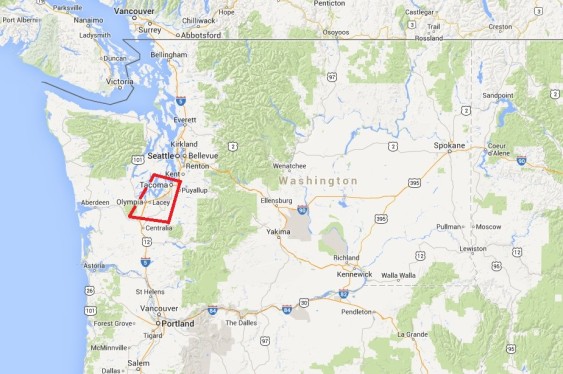
In recent years, the Northwest has seen a raft of proposals to use trains to transport coal to export terminals and crude oil to refineries and ports. To better illustrate the effects of the plans, Sightline is analyzing rail crossings from Sandpoint, Idaho to Cherry Point, Washington in a special series, The Wrong Side of the Tracks.
Large-scale rail shipping of coal and oil presents a basic physical challenge to the region’s infrastructure. The volume of cargo and the speed of the trains together dictate that coal and oil movements could shut down each street crossing for hours a day as the trains pass over public streets and roads.
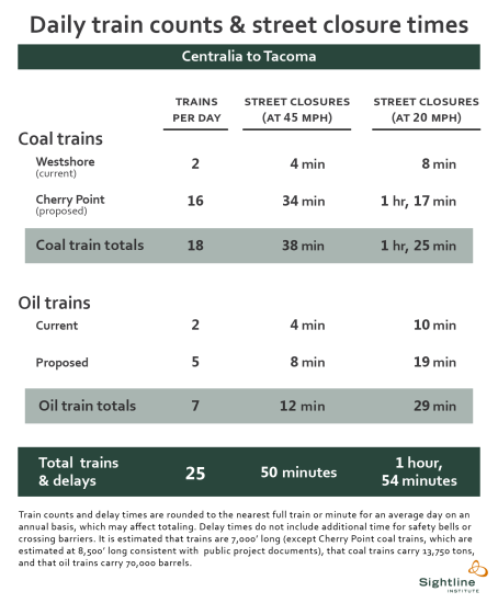
In Thurston and Pierce Counties, the region around Olympia and Tacoma, we estimate that coal and oil trains would shut down streets and roads every day from 50 minutes to 1 hour and 54 minutes, on average, if all the plans were built and operated at full capacity. That’s over and above current street closures from trains.
Please note that our analysis is not a complete account of street closures, but rather a set of examples of public at-grade crossings that would be impacted by coal and oil trains.
In our last installment, we examined street-rail interfaces in southwest Washington from Vancouver to Centralia. In this chapter we look at the next leg of the journey as trains roll into Thurston County and reach the town of Bucoda.
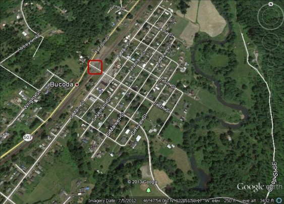
Bucoda, WA (Thurston County): 6th Street
Forty-two trains currently pass through the town of Bucoda daily. Gates protect 6th Street and its 1,400 vehicles from rail traffic. Bucoda Volunteer Park is marked by a green pine icon in the southeast portion of town.
Trains then soon reach Tenino.
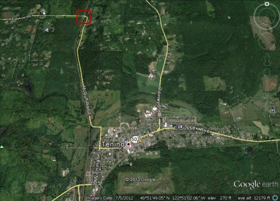
Tenino, WA (Thurston County): 143rd Avenue SE
North of Tenino, 143rd Avenue SE intersects the BNSF mainline and its 42 daily trains. The crossing is protected by gates to manage the 1,350 vehicles that travel over it each day. Near the town center are icons showing Tenino Middle School and Tenino Elementary School. The high school is located near the baseball diamond to the east of the tracks.
Continuing north, trains arrive at Lacey and the southern edge of the Puget Sound metropolitan region.
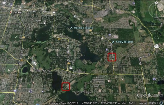
Lacey, WA (Thurston County): Atchinson Drive and Marvin Road
Coal and oil trains are expected to travel east of Olympia through Lacey where they will cross Pattison Lake on a causeway before encountering two at-grade street crossings and passing near the shore of Long Lake. Both crossings are protected by gates and currently see 40 trains a day. Marvin Road, the busier of the two streets, is traveled by 3,860 vehicles per day.
Continuing north, trains enter Pierce County and soon come to the historic town of Steilacoom.
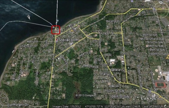
Steilacoom, WA (Pierce County): Union Avenue
Continuing into Pierce County, coal and oil trains will travel along Puget Sound beaches to reach Steilacoom and the gated at-grade crossing at Union Avenue. Union Avenue carries 14,500 vehicles per day, most of them to or from the ferry dock that provides access to Anderson Island, McNeil Island, and Ketron Island. [Ed. note: Please see the comment below by Ann Dasch for more information about this crossing.] The crossing is currently traveled by 46 trains per day, a number that would swell dramatically if planned coal and oil shipments are realized. “Child crossing” icons represent Saltars Point Elementary School, Cherrydale Elementary School, and Lake High School.
From Steilacoom, trains continue along Puget Sound, passing beside Chambers Bay Golf Course before coming to University Place.
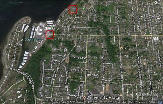
University Place, WA (Pierce County): 19th Street and 6th Avenue
Each day, 46 trains pass through the University Place crossings that give cars access to the marina and waterfront. The highest street traffic is at 19th Street, with 7,090 average daily vehicles. In the south of this image, a “children crossing” icon just north of the University Place label represents Happy Days Day Care, while the pacifier icon represents the ABC Children’s Center.
Further along Puget Sound, trains round off Point Defiance in a tunnel and turn south to arrive at the city of Tacoma.
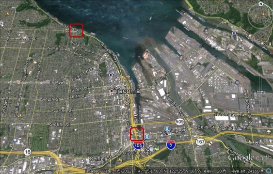
Tacoma, WA (Pierce County): McCarver Street and East 22nd Street
Multiple public grade crossings lie within Tacoma, but two with high train traffic are at McCarver Street (55 trains and 4,240 vehicles per day) and East 22nd Street (50 trains). Both are protected by gates. The green icon between the markers for State Route 705 and Interstate 5 marks the location of the Tacoma Dome.
In urban areas like Tacoma, our estimates of street closure times are almost certainly very conservative because trains must travel more slowly, and are more likely to come to a full stop on the tracks. It’s a risk that will be even more likely in King County, which we will explore in the next chapter of this series.
You can enlarge the images by clicking on them.
Click here for notes, sources, and methodology.
John Abbotts is a former Sightline research consultant who occasionally submits material that Sightline staff turn into blog posts. Thanks to Devin Porter of Goodmeasures.biz for designing the table.
Have photos of a crossing featured in this series? Share them in our “Wrong Side of the Tracks” Flickr pool.

As these trains travel up the coast, will Amtrak service possibly be affected?
Yes, it’s a very real risk.
A bit more on that here and here.
Additionally, it means that much of our public spending on passenger rail would simply amount to mitigating a deterioration in service from coal and oil freight. And it would also mean that passenger rail spending would directly or indirectly benefit coal and oil trains (because it’s all the same infrastructure). More on that here.
Eric, regarding the paragraph about Steilacoom, most cars are NOT crossing the tracks to the ferry dock. Pierce County Ferry (to Anderson Island and Ketron Island) carried fewer than 95,400 vehicles round trip in 2012 (190,800 if you count in both directions). https://www.co.pierce.wa.us/DocumentCenter/View/23884 That averages to under 525 vehicles per day. Some additional cars go by barge to McNeil, but not many (fewer than 100 per day). Nonetheless, as an Anderson Island resident, I am concerned about increased rail traffic making our ferry less reliable – train delays are already an issue during the peak summer months.
Thanks for fact-checking me, Ann!
Hello,
After seeing Ann’s comment, I decided to re-check the Federal Railroad Administration’s database. Sure enough, it lists one grade crossing in Steilacoom, at Union Ave., average daily street traffic 14,498; we rounded up by two. However, the FRA notes that they depend on voluntary reporting from the railroads for their database. Their query site can be found at https://safetydata.fra.dot.gov/OfficeofSafety/publicsite/query/invdetl.aspx
Most of the northbound Union Ave cars turn onto Rainier (which becomes Steilacoom Blvd) or Lafayette (which becomes Chambers Creek Drive north of town). Thus they do not cross the tracks.